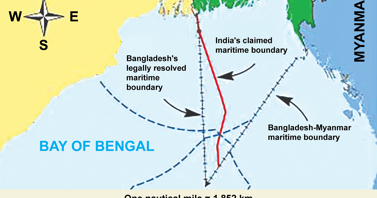
Objections to India's coastal baseline

Isa Khan

Experienced member
Moderator
Messages
6,645
Reactions
22 9,818
Nation of residence
Bangladesh
Nation of origin
Bangladesh
1631993805052.png


A part of the coastal baseline used by India to determine its maritime boundary has jutted into Bangladesh's maritime boundary. Bangladesh has tried to resolve the issue bilaterally over the past seven years, but to no avail. Finally on 13 September, Bangladesh sent a letter to the United Nations secretary general, apprising him of India's position on the issue.

Sources in Bangladesh foreign ministry have said that the letter has been sent from the Bangladesh permanent mission in the UN headquarters in New York to the UN secretary general. The letter has been published on the UN website.

In the meantime, India issued a letter to the United Nations in April, raising objections to Bangladesh's argument in favour of its claim regarding the continental shelf in the Bay of Bengal.

Bangladesh sent another letter to the UN secretary general on 13 September in response to that letter of India. In its letter, Bangladesh contended that Dhaka determined its claim to the continental shelf on the basis of the verdict passed in 2014 by the international arbitral tribunal.

A continental shelf is the part of the land of coastal countries that slopes down and is gradually submerged in the sea. The continental shelf extends straight from the baseline of the coastal countries for 350 miles. Of this, the concerned country has sovereign rights to 200 miles of this area. No other country can fish or claim mineral resources in this area. After this 200 miles, the country has sole rights to the mineral resources for the next 150 miles, but other countries can fish in these waters.

Seven years of futile efforts​

India has been using a coastal baseline since May 2009 to determine its own maritime boundary. In October 2009, Bangladesh wrote to the Indian foreign ministry, protesting against this baseline. It said that a part of this baseline was in Bangladesh's territory and requested for the error to be amended. In 2014 the international arbitral tribunal gave its verdict, determining the maritime boundary of the two close neighbours, after which Bangladesh requested for the baseline matter to be resolved bilaterally. India, however, did not respond.

Speaking to Prothom Alo about the matter on Friday evening, former foreign secretary Touhid Hossain said both sides had accepted the verdict passed by the international arbitral tribunal in 2014 regarding Bangladesh and India's maritime boundary dispute. There can be no new measures after that verdict, he said.

In a letter sent to the UN secretary general on 13 September, Bangladesh said that the matter became murky when India raised objections with the UN Commission on the Limits of the Continental Shelf in April about Bangladesh's continental shelf issue. India claimed that the baseline used by Bangladesh to determine the continental shelf was part of India's continental shelf. India requested the UN Commission on the Limits of the Continental Shelf not to take Bangladesh's claim into consideration. After that Bangladesh decided to inform the UN about the efforts made to resolve the matter bilaterally.

In its letter to the UN secretary general, Bangladesh said for long it had refrained from informing the UN and member states about the matter. Now, however, Bangladesh was clearly opposing this stand of India. Bangladesh will continue to oppose this for as long as India does not resolve the matter and inform the UN accordingly.

In its objection to India's baseline issue, Bangladesh explained that in 1976 India enacted its Territorial Waters, Continental Shelf, Exclusive Economic Zone and other Maritime Zones Act. After 33 years, in 2009, it brought about an amendment to determine the baseline. Earlier the rule was to determine the baseline from the lower level of the sea, but presently they are using the 'straight line baseline', which is contrary to Section 7 of the United Nations Convention of the Law of the Sea (UNCLOS).

While the rule is to determine the baseline from the coast, some of India's baselines are determined from the sea. The base point 87 is from the sea, around 10 nautical miles from the India coast. India's base point 89 is around 2.3 miles within Bangladesh's maritime boundary. Bangladesh is particularly concerned about this, highlighting the matter in its letter to the UN.

Secretary of the Maritime Affairs Unit of Bangladesh's foreign ministry, Admiral (retd) Md Khurshed Alam, told Prothom Alo, "The manner in which India has determined its baseline is contrary to Section 7 of UNCLOS. That is why we have put forward our objection." The Indian high commission was contacted on Friday evening for comment on the matter, but no comment has been available so far.

Letter claiming continental shelf​

Earlier in April this year, India issued a letter to the UN, objecting to Bangladesh's claims concerning the continental shelf. In the letter, India requested the UN not to take Bangladesh's claims into consideration.

Following this letter sent in April by India, Bangladesh wrote a letter to the UN secretary general on 13 September, saying that that the continental shelf had been determined in accordance to the verdict of the international arbitral tribunal in 2014. The two countries determined their maritime boundaries after this verdict was passed. The boundary point was officially declared by means of a notification. There can be no conflict after that, Bangladesh stated in its letter.

Admiral (retd) Khurshed Alam said, the UN arbitral tribunal resolved the conflict between the two sides concerning the boundary. After that, there can be no justification for any other claim to be acceptable to the United Nations.


Nilgiri

Experienced member
Moderator
Aviation Specialist
Messages
9,315
Reactions
96 18,896
Nation of residence
Canada
Nation of origin
India
India doing the same as the Chinese it seems.

Nothing even remotely the same.

PRC to begin with played zero role in the liberation and political formation of the countries it is bullying in SCS with far flung qing dynasty "maps".

That too actual building on the islands (of military nature) and attempted enforcement of exclusion zone via selective UNCLOS (while not accepting UNCLOS as a basic premise to begin with).
 

RogerRanger

Contributor
Messages
602
Reactions
444
Nation of residence
United Kingdom
Nation of origin
United Kingdom
Nothing even remotely the same.

PRC to begin with played zero role in the liberation and political formation of the countries it is bullying in SCS with far flung qing dynasty "maps".

That too actual building on the islands (of military nature) and attempted enforcement of exclusion zone via selective UNCLOS (while not accepting UNCLOS as a basic premise to begin with).
Fair enough, my comment was mistaken.
 

Lonewolf

Contributor
Messages
511
Reactions
297
Nation of residence
India
Nation of origin
India
Fair enough, my comment was mistaken.
We are doing what is permissible by UN , also there is almost zero threat to Bangladesh from India , except in case the do something fucking insane shit (not for this decade ) , they will be even provide security if they encounter out naval forces .

It's just we trying to expand our eez so that we can remove that slab for Chinese to look at as international waters outside eez
 

Jackdaws

Experienced member
Messages
2,759
Reactions
1 1,582
Nation of residence
India
Nation of origin
India
Whatever is the international arbitration procedure and law, both countries should abide by it. Disagreements with friendly countries should be resolved through amicable and legal routes.
 

Nilgiri

Experienced member
Moderator
Aviation Specialist
Messages
9,315
Reactions
96 18,896
Nation of residence
Canada
Nation of origin
India
Whatever is the international arbitration procedure and law, both countries should abide by it. Disagreements with friendly countries should be resolved through amicable and legal routes.

Canada and US actually have something similar going on for more than 150+ years (given it was inherited from British vs US dispute). There is a difference in sea boundary perceived around the Vancouver area given a dispute over an island there.

Both sides pretty much stick to their guns and have agreed to disagreed and let status quo be.

I suppose in this instance with an EEZ (for India and BD), there are fishing rights and (potential) natural gas rights involved in larger way.
 

Lonewolf

Contributor
Messages
511
Reactions
297
Nation of residence
India
Nation of origin
India
Canada and US actually have something similar going on for more than 150+ years (given it was inherited from British vs US dispute). There is a difference in sea boundary perceived around the Vancouver area given a dispute over an island there.

Both sides pretty much stick to their guns and have agreed to disagreed and let status quo be.

I suppose in this instance with an EEZ (for India and BD), there are fishing rights and (potential) natural gas rights involved in larger way.
This will be blown up when hasina lose office and that's not in near future
 

Jackdaws

Experienced member
Messages
2,759
Reactions
1 1,582
Nation of residence
India
Nation of origin
India
Canada and US actually have something similar going on for more than 150+ years (given it was inherited from British vs US dispute). There is a difference in sea boundary perceived around the Vancouver area given a dispute over an island there.

Both sides pretty much stick to their guns and have agreed to disagreed and let status quo be.

I suppose in this instance with an EEZ (for India and BD), there are fishing rights and (potential) natural gas rights involved in larger way.
Not to mention, nationalism and jingoism can get in the way.
 

Isa Khan

Experienced member
Moderator
Messages
6,645
Reactions
22 9,818
Nation of residence
Bangladesh
Nation of origin
Bangladesh

India’s objection to Bangladesh’s amended submission on the maritime boundary to the United Nations is not in line with the international law, the Bangladesh government says.​


The Commission on the Limits of the Continental Shelf (CLCS) will now make a decision considering the positions of both countries.

Based on the verdict by an international court, Bangladesh submitted an amended maritime boundary to the CLCS on Oct 27, 2020, said Khurshed Alam, secretary of the maritime affairs unit in the foreign ministry.

“India has raised an objection against our submission asking the CLCS not to consider our claim. We said it’s neither correct nor even legal.”

The arbitration to settle the dispute on the maritime boundary in the Bay of Bengal between the two neighbouring countries started back in 1974. As a series of meetings over a long period of time failed to yield an agreement, Bangladesh moved to the international court on Oct 8, 2009. The issue was shifted to the International Court of Justice in the Hague in May 2011.

In 2012, Bangladesh was awarded areas of continental shelf extending beyond 200 nautical miles of the territorial sea baselines by the International Tribunal for the Law of the Sea following a conflict with Myanmar.
Later on Jul 7, 2014, the International Court of Justice settled the delimitations of the maritime boundary of 25,500 square kilometres of the disputed area between Bangladesh, India and Myanmar and awarded 19,000 square kilometres of it to Bangladesh.

Based on that verdict, Bangladesh made an amended submission to the CLCS and India wrote to the UN secretary-general raising an objection against the amended submission on Apr 16.
Bangladesh replied on Sept 13 through a letter, which was published on the CLCS website.

India claims that Bangladesh has made a seaward shift of its exclusive economic zone (EEZ) and ‘consequently encroaches’ into the Indian EEZ recognised by the arbitration tribunal. “In this regard, Bangladesh has failed to highlight the Grey area in their amended submission,” India said.

According to the rules, in case of a dispute in delimitation of the continental shelf or maritime dispute, submissions are subject to Annex 1 of the commission procedure, India wrote in its letter. Therefore, the commission should not ‘consider and qualify’ the submission made by Bangladesh, India said.

“We have no conflict with India regarding the continental shelf. The court has settled it and we have accepted, as they have. Now, India or any other country cannot request the CLCS to ignore our submission. We have raised this point,” Secretary Khurshed Alam said.

1632491839530.png


WHAT IS CONTINENTAL SHELF

A continental shelf is a portion of a continent that is submerged under an area of relatively shallow water known as a shelf sea. Much of these shelves were exposed by drops in sea level during glacial periods. The shelf surrounding an island is known as an insular shelf.

According to the United Nations Convention on the Law of the Sea 1982, 200 nautical miles from the end tip of the land of a country is considered the continental shelf. At least 200 miles of it is considered the exclusive economic zone which falls under the jurisdiction of that country and it gets the right to use the minerals and maritime resources found there.

The rest of the continental shelf can be used by opposite or adjacent country for fishing, but minerals are the assets of the country by the bay.

According to the arbitration tribunal, Bangladesh received the ownership of 350 nautical miles of the continental shelf. The government has fixed the triangular maritime boundary with Putni Island as the end tip of land for Bangladesh.


Follow us on social media

Top Bottom