Synthetic Aperture Radar (SAR) Systems obtain high-resolution images by generating wideband RF signals and provide manned and unmanned aerial platforms with high-resolution imaging and moving target indication (GMTI) capability to detect ground and surface targets at long-range, day and night and through clouds, even in adverse weather conditions such as rain, snow, fog, cloud, and smoke. SAR Systems can be used in reconnaissance and surveillance applications in the military as well as in post-disaster damage assessment and crisis management, city planning, and mapping applications in the civilian field.
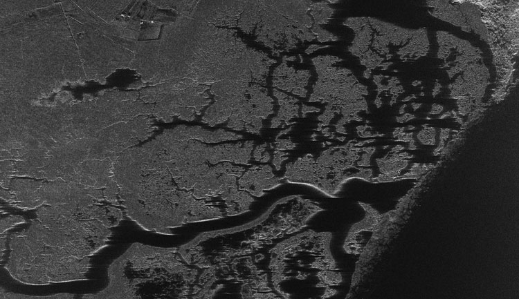
Issue 102A Synthetic Aperture Radar is a side-looking radar system that utilizes the platform’s flight path to simulate an extremely large antenna or aperture electronically and generates high-resolution remote sensing imagery. SAR is used to create two-dimensional images or three-dimensional reconstructions of objects using the radar antenna’s motion over a target region to provide finer spatial resolution than conventional beam-scanning radars. SAR works similarly to a phased array, but contrary to several parallel antenna elements of a phased array, SAR uses one antenna in time-multiplex. The distance the SAR device travels over a target in the time taken for the radar pulses to return to the antenna creates the large synthetic antenna aperture. Typically, the larger the aperture, the higher the image resolution will be, regardless of whether the aperture is physical (a large antenna) or synthetic (a moving antenna) – this allows SAR to create high-resolution images with comparatively small physical antennas. Additionally, SAR has the property of having larger apertures for more distant objects, allowing consistent spatial resolution over a range of viewing distances. Contrary to FLIR optical imaging systems, the SAR/GMTI Radar System can operate day and night in all weather conditions because it uses the reflections of RF signals generated by its own antenna, not the reflection of sunlight. Unlike FLIR systems, which allow very detailed surveillance in an area of about 150m x 150m during day and night (200m x 200m with AselFLIR-300T used in GÖZCÜ-I/Heron and ANKA Block-A/B UAVs and 130m x 130m with AN/AAS-52 used in MQ-1 Predator UAV), the SAR/GMTI System allows the user to view a larger area at high resolution even in adverse weather conditions (Since the field of view is very limited, using a FLIR is defined as ‘looking through a straw or finding a needle in a haystack’). While optical systems (FLIR) can produce images in sub-seconds (about 24 frames per second) at vertical viewing angles such as 0-20 degrees, the SAR/GMTI Radar System can generate images in seconds (can take 1 minute in some cases) at more horizontal angles such as 20-85 degrees (which gives the user a stand-off range advantage), depending on the speed and viewing range of the carrier platform. While numerous images can be obtained in an ever-increasing number with optical systems, only a single image can be generated with SAR/GMTI Systems.
We can summarize the main advantages of radar imaging compared to optical imaging as follows:
Day/night, all-weather capability,
Long-range,
High-resolution,
Wide area imaging,
Moving target detection.
Additionally, precise measurements such as High-Resolution Imaging (SAR), Digital Elevation Model (DEM), and Coherent Change Detection (CCD) can be acquired using the phase information (bit depth) of the RF signal generated by the SAR/GMTI Systems. SAR/GMTI radars generally operate in X-Band (3cm) and can acquire changes in 1/4 and 1/8 of the wavelength from the phase information. Therefore, almost mm-level changes can be seen in the phase information (Coherent Change Detection). This allows the user to detect specific phase-coherent changes, create digital elevation models, and display high resolution by increasing the bandwidth.
There are two methods of obtaining a SAR image: Offline and Online. In the offline mode, the image (in the form of raw data) is transferred to a ground computer via a data transfer unit (downlink), then this data is processed, and the image is created. On the other hand, in the online mode, the image is produced in-flight by the system; however, this method requires more processing capacity. In this way, the UAV/aircraft can directly transfer the image to the Ground Control Station (GCS) via the Ground Data Terminal (GDT), providing instant detection and identification capability.
As noted above, unlike the optical system, the radar provides phase information (bit depth) to the operator and uses this data while processing the radar image (using a Change Detection Algorithm). Additionally, moving targets can be superimposed on the SAR image displaying land vehicles’ movement on the road (GMTI Mode). Moreover, Inverse Synthetic Aperture Radar (ISAR) systems can also display the movement of maritime targets (Maritime Moving Target Indicator/MMTI Mode). The optical systems can be fooled using camouflage, but it is much more difficult to deceive the radar systems as the electromagnetic signals can penetrate under the cover. It is even possible to determine whether the soil has just been dug or not with the thermal systems. Temperature differences at a certain point in the thermal image can be detected after a certain period. For example, after four hours, the environmental temperature reaches an equilibrium; in this case, the thermal systems cannot correctly identify the differences. However, since specific environmental changes, such as disturbed soil or broken vegetation, do not immediately return to its original form, these differences can be detected more easily with radar systems. Using advanced algorithms, such changes can be automatically detected, and the traces can be acquired with the SAR image. Since such algorithms cannot commonly be purchased from abroad, the domestic capabilities gained in this field are vital regarding the development of indigenous SAR systems.
The history of the Synthetic (Artificial) Aperture Radar System goes back to the 1950s. The first patent of the SAR System was granted in the USA in 1956. It had initially emerged as an idea in the 1950s. The first military applications of SAR started in 1953 and were introduced with a system completed in 1960. The first operational SAR Satellite, SeaSAT, was launched on June 27, 1978, and after 105 days in orbit, it went out of service on October 10, 1978.
As far as I know, the first SAR/GMTI capable military air radar used in Turkey was the Israeli IAI/Elta product EL/M-2032 Firing Control Radar, which was first delivered to the Turkish Air Force with F-4E 2020 Phantom II aircraft on January 27, 1999. The EL/M-2032 Radar can provide SAR/GMTI images at 1-1.5m resolution. The first SAR/GMTI sensor procured for Unmanned Aerial Vehicles (UAV) was the EL/M-2055DX SAR/GMTI radar (50kg), which was delivered with the first batch of 6 GÖZCÜ-I/Heron MALE UAV Systems in February 2010 and was officially accepted on April 8, 2010. Commander of the 1st Air Force Operations Group of the time, Colonel BALOĞLU, who informed us at the AK-2010/1 Training held on April 19-30, 2010, stated that the GÖZCÜ-I UAV was able to obtain 30cm resolution photos day and night thanks to its EL/M-2055DX SAR/GMTI radar. In the meantime, under the Turkish Unmanned Aerial Vehicle (TUAV) Development Program, which was initiated to meet the UAV requirement of the TAF in the MALE configuration through a national product, a contract worth US$62 million (subsequently, this figure increased to approximately US$96,437 million) was signed between the Main Contractor Turkish Aerospace (TUSAŞ) and the SSB on December 24, 2004, for the development of an indigenous UAV System consisting of three MALE Class ANKA UAVs, one Ground Control Station (GCS), one Transportable Image Exploitation System (TIES), two Ground Data Terminals (GDT), three Day/Night Cameras, two Radars (SAR/GMTI-ISAR Radar developed under a different contract), and an Automatic Landing/Takeoff System (Radar based and with GPS backup).
P-235 (CN235-100M) Maritime Patrol Aircraft, which were procured under the Meltem-II Project and equipped with the Ocean Master 400 Volume Search Radar (400W) with a 190nm range, became operational in October 2013. The Ocean Master 400 Radar, which can simultaneously track up to 200 targets, can also generate high-resolution SAR and ISAR images. According to the information we have obtained, during a joint test with the TNFC, the domestic SAR/GMTI-ISAR Radar on the S-2E/T Flying Test Platform was able to acquire a higher quality SAR image than the Ocean Master 400 Radar on the P-235 MPA, which has both SAR and ISAR Modes.
Another SAR system that was used in Turkey was the Thales product I-MASTER GMTI/MMTI/SAR Radar. It was used in the second Beechcraft King Air 350i Manned Airborne Intelligence, Surveillance, and Reconnaissance (MAISR) Aircraft procured by the General Directorate of Security Aviation Department in 2016. The Ku-Band I-Master GMTI/MMTI/SAR Radar weighs only 30kg and has 360-degree coverage day and night in all weather conditions. The radar can obtain the images of land and surface targets from a range of 35km at low resolution (3m) and 27km at high resolution (30cm) at +10/-55 degree viewing angles. The I-Master Radar, with GMTI (Ground Moving Target Indicator), MMTI (Maritime Moving Target Indicator), and SAR (Synthetic Aperture Radar) capabilities, is placed inside a 15-inch diameter EO/IR sensor turret. According to the product brochure the I-Master Radar provides GMTI and MMTI images simultaneously and can scan an area of over 800 km² per hour in SAR Mode and detect vehicle and human movements on the ground from a maximum range of 20 km in GMTI Mode. Initially, problems were experienced during the I-MASTER Radar’s integration process to the King Air 350i MAISR due to ITAR restrictions, and some of the radar’s capabilities were stated to be limited, but these problems were solved later through further negotiations. The first King Air 350i aircraft of the Police Aviation Department equipped with the Thales product I-MASTER GMTI/MMTI/SAR Radar crashed on Mount Artos in Van’s Gevaş District on July 15, 2020, at an altitude of 2,200m and 7 police officers, 2 of which were pilots died in the accident.
As stated above, six EL/M-2055DX SAR/GMTI Radars from Israel were supplied by IAI/Elta for Heron MALE UAVs operated by the Turkish Air Force (TurAF). Developed for UAV platforms, the EL/M-2055 advanced tactical reconnaissance system provides the user with high-resolution SAR images of the target area in all weather conditions. The radar can operate in three different modes (GMTI, SAR Strip, and SAR Spot), and there are three different versions of the radar developed primarily for use in MALE and Tactical UAVs. The EL/M-2055M model radar has a power consumption of 2,000W and a weight of 80 to 100kg. It is used in high-altitude MALE UAVs and long-range reconnaissance aircraft and can scan 10,000 km² per hour at a range of over 100 km. The bigger EL/M-2055M radar consists of 3 LRUs, a radar processor, a high-energy transmitter, and a wide-angle antenna array that obtains images with a resolution of 3 to 1 meter in the SAR Strip Mode to identify fixed and stationary targets and can acquire 60, 30, and 10cm resolution images in the SAR Spot Mode to gather more detailed information about the target. The lighter version, EL/M-2055DX, consists of 2 LRUs with the transmitter and antenna fitted to a single module. It weighs 50kg and has a range of 50km and can scan an area of 2,000km² per hour. The EL/M-2055DX has an energy consumption of 850W and can be used in both medium-sized Tactical and MALE UAV platforms and Light Reconnaissance Aircraft. The EL/M-2055D version, which has 1 LRU, medium power transmitter, and a compact antenna, is developed for Tactical UAVs and has a range of 35km and can scan an area of 2,000km² per hour. The 38kg EL/M-2055D has an energy consumption of 800W.
The fifth SAR/GMTI sensor used in Turkey for military/security purposes was also the first domestic design and production SAR System of Aselsan, SARPER™ National SAR/MTI/ISAR Radar. Although the TurAF was initially believed to be the first user of the system, the first customer of the SARPER™ National SAR/MTI/ISAR Radar was the Turkish Naval Forces Command. The SARPER™ Radar is currently used in three ANKA Block-B UAV Systems operated by the TNFC, and the 4th ANKA Blok-B UAV is equipped with the new version of the system, SARPER+ SAR/ISAR/Maritime Search radar with an increased range. According to the press release published by Turkish Aerospace (TUSAŞ) on August 24, 2020, the 4th ANKA Block-B UAV equipped with the SARPER + Radar was delivered to the TNFC in August. Under the contract signed in 2019, the TNFC ordered an additional 4 ANKA Block-B and 8 ANKA-S UAVs.
Meteksan Defence MILSAR SAR/GMTI Radar
The Meteksan Defence product MILSAR SAR/GMTI Radar was exhibited for the first time at the IDEF ‘19 Fair. It is quite similar to the Thales product I-MASTER GMTI/MMTI/SAR Radar and is considered to be the best product of its segment in terms of outer shell appearance.
Initially, the multi-functional radar system MILSAR had different technical specifications (Ka-Band and a 10km range). However, after a system similar to the I-MASTER was requested by both the SSB and other UAV platform manufacturers, including Baykar Defence, Meteksan Defence transformed it into a SAR/GMTI Radar with comparable capabilities to the I-Master. After a change in the contract, the frequency range of MILSAR was changed (Ku-Band), its range was increased (27km), resulting in a product that is 1-2 kg lighter than the I-MASTER. According to the information we have obtained, MILSAR is stated to have similar characteristics as the I-MASTER in terms of performance and can generate radar images up to 30cm resolution from a 27km range. MILSAR is expected to have a detection range up to 83km in Surface Search Mode. Having the same mechanical interface as the standard 15-inch EO/IR FLIR turret (in this way, MILSAR can be installed instead of EO/IR payload when necessary), MILSAR provides Tactical UAVs with 360-degree scanning and surveillance capability independent of weather conditions.
MILSAR operates in Strip or Spot Modes like other SAR systems and can produce images at 1m resolution in Strip Mode and display them to the operator as a continuous video feed. The bandwidth required for transferring images to the Ground Control Station is compatible with existing UAV data links. Moreover, using the new C-Band Data Link developed by Meteksan Defence, which can share data up to 13Mb per second at a range of over 200km and provides reliable communication with its frequency hopping/spread spectrum feature (FHSS&DSSS), the bandwidth that can be allocated for this task can be increased even further. Additionally, MILSAR can generate 30cm resolution images of the target area in Spot Mode, and Meteksan Defence is currently working with Bilkent University to provide MILSAR with the Coherent Change Detection (CCD) feature. The ground segment of the MILSAR System, which can produce SAR/GMTI images on its own during the flight/mission and display it to the operator, also incorporates image processing software that will run the Coherent Change Detection (CCD) feature. MILSAR tracks moving targets on the ground thanks to its GMTI capability and will also have DMTI and MMTI Modes as an option. A Meteksan Defence representative, that I had the opportunity to meet at the IDEF ’19 Fair, stated in response to my question that the system does not have ISAR Mode currently, but the first prototype of MILDAR has the ISAR feature, so they have the necessary algorithms for this capability. The Meteksan Defence official said, “ISAR is a software add-on. We can add ISAR capability to MILSAR with a software upgrade, but it is not included in the project requirements.” Although tactical UAVs were initially considered to be the carrier platform for MILSAR, the system can also be used with EO/R FLIR payloads in larger class UAVs such as AKINCI and AKSUNGUR or a Maritime Patrol Aircraft (MPA). The Meteksan Defence representative also had stated that they aimed to start flight tests with MILSAR in August 2019 within the framework of the Turkish National Police (TNP) request. In this context, the company carried out meetings with Baykar Defence and Turkish Aerospace regarding the flight tests. Meteksan Defence considered the ANKA MALE UAV, BAYRAKTAR TB2 Tactical UAV, or S-2E/T aircraft as test platforms at that time. Eventually, it added the Turkish Aeronautical Association’s ‘test-bed’ Cessna aircraft, which has a suitable mounting point for MILSAR, among its platform alternatives.
Meteksan Defence started the development studies of MILSAR in 2007 within the scope of the MILDAR Program. MILSAR, a unique design of Meteksan Defence, incorporates several innovations, especially in power amplification. A highly advanced antenna design is used in MILSAR, which has a very compact structure. The company aims to re-use this antenna design in its Helicopter MILDAR product. Furthermore, as MILSAR is required to be light, it is designed to be air-cooled. Although an active fan-based cooling system would allow MILSAR to operate in higher temperature ranges than passive air cooling, this would increase both power consumption and weight of the system

Turkey’s SAR/GMTI Radar Capabilities
Synthetic Aperture Radar (SAR) Systems obtain high-resolution images by generating wideband RF signals and provide manned and unmanned aerial platforms with high-resolution imaging and moving target i
 www.defenceturkey.com