
Latest Thread
- Israel threatens China
- Ukraine ChME3 Diesel Locomotives,drone protected
- CYBINT/DNINT Intelligence Exchange Between South Korea's NIS and Russia's GRU: Potential U.S. Challenges Ahead
- China Fujian carrier has launched & landed J-15T, J-35 & KJ-600 jets using electromagnetic catapults
- Bangladesh Army Bangladesh Army participates in 'WEST-2025' in Russia
You are using an out of date browser. It may not display this or other websites correctly.
You should upgrade or use an alternative browser.
You should upgrade or use an alternative browser.


Scott Summers
Contributor
ExconMobil starts drilling in Block 5 after South Cypriotic Navtex.

 en.protothema.gr
EXXON MOBIL starts drilling for natural gas in the Cypriot EEZ - ProtoThema English
The Republic of Cyprus today issued NAVTEX for the commencement of drilling in Block 5
en.protothema.gr
Would be nice if there was a map. Block 5 only partially covers our EEZ.ExconMobil starts drilling in Block 5 after South Cypriotic Navtex.
EXXON MOBIL starts drilling for natural gas in the Cypriot EEZ - ProtoThema English
The Republic of Cyprus today issued NAVTEX for the commencement of drilling in Block 5

That scrap oil rig that went a ground in Tunesia, needs to be freed and brought to Izmir fast.
MoD is following the drill rig Exxon mobile and as it is 11.5 miles away from our EEZ, we'll continue observing them
Scott Summers
Contributor
Turkish F-16 violates “Greek” airspace.
They think whole the Agean and East Med is Hellenic.

 www.tovima.com
They think whole the Agean and East Med is Hellenic.
Turkish Fighter Jet Violates Greece's Airspace
Turkish Fighter Jet - Reports from Vimatodotis suggest that the Turkish pilot either did not realize where he was flying or was simply
www.tovima.com

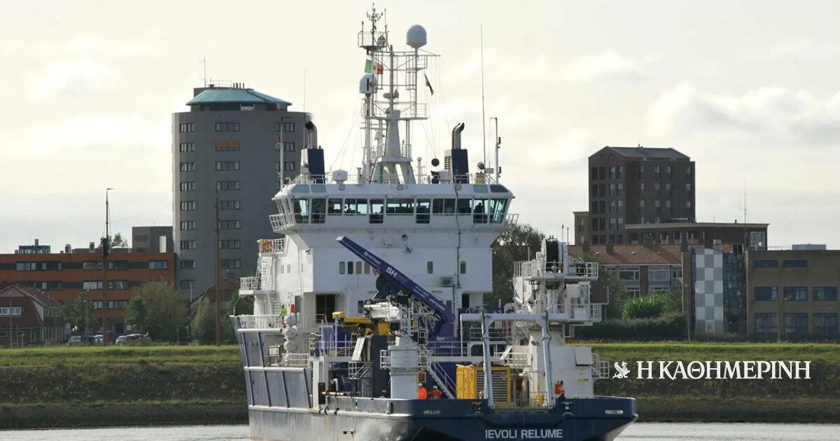
"The Great Sea Interconnector-2GSI project between Greece and Cyprus is officially put on ice until further notice, following ADMIE's decision to suspend funding. The project was effectively halted in July 2024 when, south of Kasos, Turkish warships intercepted the course of an Italian ship conducting surveys for the project. The attitude of the Turks at a stage of the project that had not even come close to laying a cable, but was foundering at the initial stage of surveys, as well as the inability to find a compromise through direct Greek-Turkish discussions made continuation extremely difficult. The government, however, is attempting to buy time, without further financial cost and with a view to exploring whether in the next phase the obstacles will disappear. At this stage, where Ankara is attempting to deepen its relations with the EU, anything can be used as a bargaining chip and therefore nothing can be considered definitive. However, on Wednesday evening the research vessel "Ievoli Relume" left Crete for Sicily, while two weeks earlier it was preceded by the "NG Worker". Both were active in research for the electrical interconnection."
 www.kathimerini.gr
«Παγώνει» το καλώδιο με Κύπρο
Αποχώρησε από την Κρήτη και το δεύτερο ερευνητικό πλοίο «Ievoli Relume».


Ther failure is our success, good for them....

 www.mees.com
Cyprus Gas Dreams Take Hit As Exxon’s Elektra Well Flops
Cyprus’ hopes of discovering up to 30tcf of gas at US major ExxonMobil’s Elektra well have been crushed after drilling results disappointed.
www.mees.com
Last edited by a moderator:
Türkiye Marine Spatial Planning Map is now available!
A large scale version of the map for those who are curious
@Sanchez @Rooxbar @TR_123456

Türkiye continues work on marine park plans in Aegean Sea: State media - Türkiye News
Türkiye is closely monitoring Greece’s forthcoming announcement, expected by the end of the month, regarding the establishment of marine protected areas in the Ionian and Aegean seas, while simultaneously accelerating its own relevant efforts, the Turkish state-run Anadolu Agency said, citing...
Very good moves. And if course TCG needs capabilities to safeguard it.
Türkiye Marine Spatial Planning Published on MSPGlobal Platform
The “Turkey Marine Spatial Planning Map” prepared under the coordination of DEHUKAM and with the contributions of all relevant institutions and organizations, has been registered by the Republic of Turkey with IOC-UNESCO after being shared with the public on April 16, 2025. With the completion of the registration process, the TURKEY DMP map has been published on the MSPGlobal platform and opened to international access.
This important development has ensured that Turkey’s spatial planning for the sustainable use of its marine and coastal areas has gained international recognition and official status.

Libya Condemns Greek Hydrocarbon Tender in Disputed Mediterranean Waters
Benghazi, June 20, 2025 The Ministry of Foreign Affairs and International Cooperation of the Libyan Government has issued a strong statement denouncing a recent
 libyaupdate.com
Greecs trying to steal Libyan waters...


The Aegean dispute and the Turkish strategic doctrine of the “Mavi Vatan” - Πτήση
By Georgios Kalafikis, Ph.D. Greece should always and suitably repel Turkey’s expansionist claims (in whatever form or frequency) against Greek land, sea, and airspace before the eyes and minds of the international community, for two reasons: first, the current Greco-Turkish confrontation and...
 flight.com.gr
1) “All Greek islands of the Eastern Aegean constitute an extension of the Anatolian Plate; hence, they settle on a potential Turkish continental shelf and they are not entitled to any of their own”.
First, the concepts of the “continental shelf” and the “tectonic plates” cannot be adjoined in the inaccurate manner of the Turkish side, nor can they be connected according to the aspirations of the Turkish establishment! According to Geology, the “Anatolian tectonic plate” does not protrude into the Aegean Sea; on the contrary, the “Aegean or Hellenic tectonic plate” includes the Turkish coastline of the Aegean and extends further into western Anatolia (Asia Minor).
Secondly, according to the “United Nations Convention on the Law of the Sea” (UNCLOS), every juridical island is entitled to a continental shelf and an EEZ in equal principle with any other corresponding mainland, besides the legal territorial sea of up to 12 nautical miles. The UNCLOS treaty and the relevant decisions of international tribunals cannot be invoked a la carte by a non-contracting state, such as Turkey, which not only hasn’t signed it yet but still rejects it as an instrument for interpreting the Law of the Seas.
Until very recently, Greece had been the only (!) country in the world to possess a ubiquitous territorial sea of just 6 nautical miles strictly and only measured by the shorelines and not by applying “straight baselines” after designating its many bays and gulfs as “internal waters” or “historic bays” (at last, Greece used those methods for the enlargement of the Greek territorial waters in the Ionian Sea. It is worth mentioning that “straight baselines” increase the outline of the coastlines and also expand the starting basis for the calculation of the territorial waters, thus enlarging the territorial sea). Moreover, Greece is, unfortunately, the only (!) country worldwide to bear an official and perpetual threat of a “casus belli” formally declared by Turkey – an otherwise NATO “ally” – in case Greece legally extends its Aegean territorial waters from 6 to 12 nautical miles, a right provided by international conventions without impeding the maritime traffic and the global navigation in any way.
The possibility of a unilateral but legal extension of the Greek territorial waters to 12 miles in the Aegean through “straight baselines” as well as by designating most Greek gulfs as “internal waters” or “historic bays” would automatically put an end to the Aegean Question. Then, the Greek territorial waters/territorial sea would cover approximately ¾ (75%) of the total area of the Aegean basin; hence, only a few parts of the Aegean would remain in a “High seas” status and potentially dividable between Greece and Turkey. That’s the key reason for the existence of the illegitimate Turkish casus belli against Greece.
In reality, a friendly and cooperative Turkey has nothing to fear because Greece has neither the intention nor the capacity to block Turkey’s exit to the High Seas by exercising a blockade in the semi-enclosed Aegean Sea, in turn, a part of the enclosed Mediterranean Sea. Being a country that habitually abides by International Law and a maritime nation that considers the “Freedom of the Seas” as a vital “national interest”, Greece has already explicitly declared by signing the UNCLOS that (quote) it “has the responsibility to designate the route or routes” for “the international navigation” through its “numerous spread-out islands” that often “form a great number of alternative straits” to apply “in practice” all relevant articles of the UNCLOS. Indeed, that’s what Greece is doing and permitting anyway (cf. the MarineTraffic screenshot). Therefore, Turkey’s retrospective fears only reflect its malicious aims against Greece, as we shall demonstrate next.
4) Finally, the very theory and policy of the so-called Turkish “Azure Homeland” (Mavi Vatan) is offensive through a simple juxtaposition to the map. Such a hypothetical, intolerable to Greece and Cyprus, Turkish EEZ would “engulf” hundreds of Greek islands and almost the entire Cypriot EEZ! The possibility of the Aegean Greek islands and Cyprus merely “floating” upon a “Turkish” sea is unrealistic beyond any reasonable doubt. A possible “encapsulation” of several hundred densely packed foreign islands into a foreign EEZ is a fallacy by definition in stark contrast to any principle or provision of International Law. Such likelihood becomes an illusion because in International Law no regulation exists that allows for a foreign opposite or adjacent coastline to extend its EEZ over and beyond a whole foreign chain of islands. That would be to the detriment of all the intermediate foreign islands. Practically, whole clusters and groups of Greek islands would be separated and cut off from the rest of the Greek national territory, even though they are geographically inseparable from each other and the Greek mainland.
That’s why the “sea blockade” that allegedly Turkey is afraid of being imposed by Greece is what Turkey aspires to impose on Greece instead! Exactly how? By precisely aspiring to close off all the Greek islands up to the middle of the Aegean and even Cyprus within an enormous “Turkish territorial sea, continental shelf and EEZ”, Turkey’s “Azure Homeland”. Therefore, Greece may condemn the Turkish strategic plans for expansion even by associating the “Mavi Vatan” with Italy’s “Mare Nostrum” and Germany’s “Lebensraum”!
To sum up, the implicit and explicit goal of 21st-century revisionist Turkey is to absorb Greek seas, land, islands, and airspace. That is the essence of the contemporary Greco-Turkish utterly problematic and quasi-hostile relations. Another graphic – though strangely neglected – detail aptly reveals that the Greek Aegean islands do not even enjoy the right to the minimum legal territorial sea of 6 nautical miles in all the Turkish “Mavi Vatan” maps! So, according to the Turkish fallacious and expansionist intentions, they already seem to belong to Turkey proper!
The Aegean dispute and the Turkish strategic doctrine of the “Mavi Vatan” - Πτήση
By Georgios Kalafikis, Ph.D. Greece should always and suitably repel Turkey’s expansionist claims (in whatever form or frequency) against Greek land, sea, and airspace before the eyes and minds of the international community, for two reasons: first, the current Greco-Turkish confrontation and...
1) “All Greek islands of the Eastern Aegean constitute an extension of the Anatolian Plate; hence, they settle on a potential Turkish continental shelf and they are not entitled to any of their own”.
First, the concepts of the “continental shelf” and the “tectonic plates” cannot be adjoined in the inaccurate manner of the Turkish side, nor can they be connected according to the aspirations of the Turkish establishment! According to Geology, the “Anatolian tectonic plate” does not protrude into the Aegean Sea; on the contrary, the “Aegean or Hellenic tectonic plate” includes the Turkish coastline of the Aegean and extends further into western Anatolia (Asia Minor).
Secondly, according to the “United Nations Convention on the Law of the Sea” (UNCLOS), every juridical island is entitled to a continental shelf and an EEZ in equal principle with any other corresponding mainland, besides the legal territorial sea of up to 12 nautical miles. The UNCLOS treaty and the relevant decisions of international tribunals cannot be invoked a la carte by a non-contracting state, such as Turkey, which not only hasn’t signed it yet but still rejects it as an instrument for interpreting the Law of the Seas.
Until very recently, Greece had been the only (!) country in the world to possess a ubiquitous territorial sea of just 6 nautical miles strictly and only measured by the shorelines and not by applying “straight baselines” after designating its many bays and gulfs as “internal waters” or “historic bays” (at last, Greece used those methods for the enlargement of the Greek territorial waters in the Ionian Sea. It is worth mentioning that “straight baselines” increase the outline of the coastlines and also expand the starting basis for the calculation of the territorial waters, thus enlarging the territorial sea). Moreover, Greece is, unfortunately, the only (!) country worldwide to bear an official and perpetual threat of a “casus belli” formally declared by Turkey – an otherwise NATO “ally” – in case Greece legally extends its Aegean territorial waters from 6 to 12 nautical miles, a right provided by international conventions without impeding the maritime traffic and the global navigation in any way.
The possibility of a unilateral but legal extension of the Greek territorial waters to 12 miles in the Aegean through “straight baselines” as well as by designating most Greek gulfs as “internal waters” or “historic bays” would automatically put an end to the Aegean Question. Then, the Greek territorial waters/territorial sea would cover approximately ¾ (75%) of the total area of the Aegean basin; hence, only a few parts of the Aegean would remain in a “High seas” status and potentially dividable between Greece and Turkey. That’s the key reason for the existence of the illegitimate Turkish casus belli against Greece.
In reality, a friendly and cooperative Turkey has nothing to fear because Greece has neither the intention nor the capacity to block Turkey’s exit to the High Seas by exercising a blockade in the semi-enclosed Aegean Sea, in turn, a part of the enclosed Mediterranean Sea. Being a country that habitually abides by International Law and a maritime nation that considers the “Freedom of the Seas” as a vital “national interest”, Greece has already explicitly declared by signing the UNCLOS that (quote) it “has the responsibility to designate the route or routes” for “the international navigation” through its “numerous spread-out islands” that often “form a great number of alternative straits” to apply “in practice” all relevant articles of the UNCLOS. Indeed, that’s what Greece is doing and permitting anyway (cf. the MarineTraffic screenshot). Therefore, Turkey’s retrospective fears only reflect its malicious aims against Greece, as we shall demonstrate next.
4) Finally, the very theory and policy of the so-called Turkish “Azure Homeland” (Mavi Vatan) is offensive through a simple juxtaposition to the map. Such a hypothetical, intolerable to Greece and Cyprus, Turkish EEZ would “engulf” hundreds of Greek islands and almost the entire Cypriot EEZ! The possibility of the Aegean Greek islands and Cyprus merely “floating” upon a “Turkish” sea is unrealistic beyond any reasonable doubt. A possible “encapsulation” of several hundred densely packed foreign islands into a foreign EEZ is a fallacy by definition in stark contrast to any principle or provision of International Law. Such likelihood becomes an illusion because in International Law no regulation exists that allows for a foreign opposite or adjacent coastline to extend its EEZ over and beyond a whole foreign chain of islands. That would be to the detriment of all the intermediate foreign islands. Practically, whole clusters and groups of Greek islands would be separated and cut off from the rest of the Greek national territory, even though they are geographically inseparable from each other and the Greek mainland.
That’s why the “sea blockade” that allegedly Turkey is afraid of being imposed by Greece is what Turkey aspires to impose on Greece instead! Exactly how? By precisely aspiring to close off all the Greek islands up to the middle of the Aegean and even Cyprus within an enormous “Turkish territorial sea, continental shelf and EEZ”, Turkey’s “Azure Homeland”. Therefore, Greece may condemn the Turkish strategic plans for expansion even by associating the “Mavi Vatan” with Italy’s “Mare Nostrum” and Germany’s “Lebensraum”!
To sum up, the implicit and explicit goal of 21st-century revisionist Turkey is to absorb Greek seas, land, islands, and airspace. That is the essence of the contemporary Greco-Turkish utterly problematic and quasi-hostile relations. Another graphic – though strangely neglected – detail aptly reveals that the Greek Aegean islands do not even enjoy the right to the minimum legal territorial sea of 6 nautical miles in all the Turkish “Mavi Vatan” maps! So, according to the Turkish fallacious and expansionist intentions, they already seem to belong to Turkey proper!
This is not Turkish EEZ but Libyan EEZ...
Libyan government rejects Greek objections to deal with Türkiye
BENGHAZI

Libya’s eastern-based government has firmly rejected recent Greek objections to the 2019 maritime boundary agreement signed between Türkiye and the Tripoli-based Libyan government, asserting that the deal remains legitimate under international law.
Prime Minister Osama Hammad, representing the Benghazi-based administration, stated that the Türkiye-Libya deal is "internationally legitimate" and warned against any external interference in Libya’s sovereign decisions.
“Libya will not accept any challenge to its rights,” he said, adding that the country retains the right to respond decisively to any actions threatening its territorial integrity or political sovereignty. He also accused Greece of pursuing a "policy of provocation and escalation."
Hammad stressed that Libya’s maritime rights are non-negotiable and must be discussed only within internationally recognized legal frameworks. He noted that decisive steps were taken in response to Athens’ recent positions and warned that continued Greek objections would trigger consequences.
The Tripoli government and Türkiye signed the maritime boundary agreement in 2019, which delineated exclusive economic zones in the eastern Mediterranean. In 2022, the two sides expanded the deal with a memorandum granting Türkiye exploration rights both offshore and on Libyan territory.
Recently, Libya’s eastern-based administration has decided to establish a technical committee to reexamine the 2019 maritime deal. The move is seen as part of a recent thaw in relations between Ankara and the eastern Libyan administration.
The flare-up followed the signing of a new memorandum of understanding on June 25 between Türkiye’s state-owned energy company TPAO and Libya’s National Oil Corporation (NOC), aimed at conducting seismic research in areas covered by the 2019 maritime boundary deal.
Greek Prime Minister Kyriakos Mitsotakis brought the issue to the European Union summit in Brussels last week, once again questioning the validity of Türkiye’s maritime agreements with Libya.
The summit’s final communique emphasized that the Türkiye–Libya memorandum “violates the sovereign rights of third countries and is not in line with the international law.”
Additionally, the EU Council deemed the memorandum unlawful and expressed support for the positions of Greece and the Greek Cypriot Administration.
In response, Türkiye said that the outcomes of the EU leaders' summit show that Greece and Greek Cyprus continue efforts to “impose their maximalist claims.”
The deal is an “entirely legitimate agreement" under international law, Turkish Foreign Ministry Spokesman Öncü Keçeli wrote on X.
"In this regard, instead of endorsing legally invalid claims, the EU should call on all its members to comply with international law," he said.

Libyan government rejects Greek objections to deal with Türkiye - World News
Libya’s eastern-based government has firmly rejected recent Greek objections to the 2019 maritime boundary agreement signed between Türkiye and the Tripoli-based Libyan government, asserting that the deal remains legitimate under international law.
Turkey has purchased two new drilling ships to be used in natural gas exploration
The Turkish Petroleum Corporation (TPAO) has purchased the drilling ships from Norwegian Eldorado Drilling. The purchased ships are the 2014-built West Draco and the 2015-built West Dorado
It was stated that the two ships purchased will be used in Libya and the Mersin offshore, and $245 million was paid per ship

 www.haberdenizde.com
The Turkish Petroleum Corporation (TPAO) has purchased the drilling ships from Norwegian Eldorado Drilling. The purchased ships are the 2014-built West Draco and the 2015-built West Dorado
It was stated that the two ships purchased will be used in Libya and the Mersin offshore, and $245 million was paid per ship
Türkiye'den yeni sondaj hamlesi : ikizler geliyor
TPAO'nun satın aldığı yeni sondaj gemileri, Karadeniz ve Mersin Taşucu'nda kullanılacak.