


Satellite images of massive Chinese construction 50 km from the LAC in Aksai Chin (High res: Herehere)
The site identified in this report lies in Aksai Chin, East of the Line of Actual Control, in territory held by China and historically claimed by India.
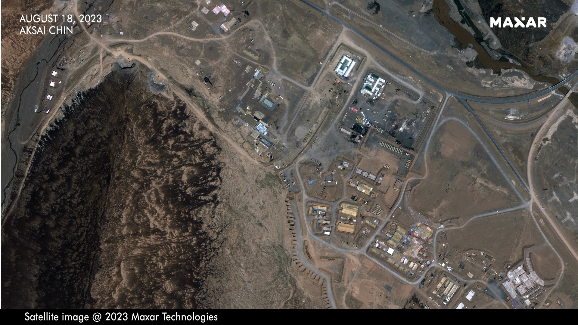
Sixty kilometres east of the Depsang Plains in Northern Ladakh, Chinese forces have begun carving tunnels and shafts into a hillside along a narrow river valley to construct multiple reinforced shelters and bunkers for soldiers and weaponry.
The site identified in this report lies in Aksai Chin, East of the Line of Actual Control, in territory held by China and historically claimed by India.
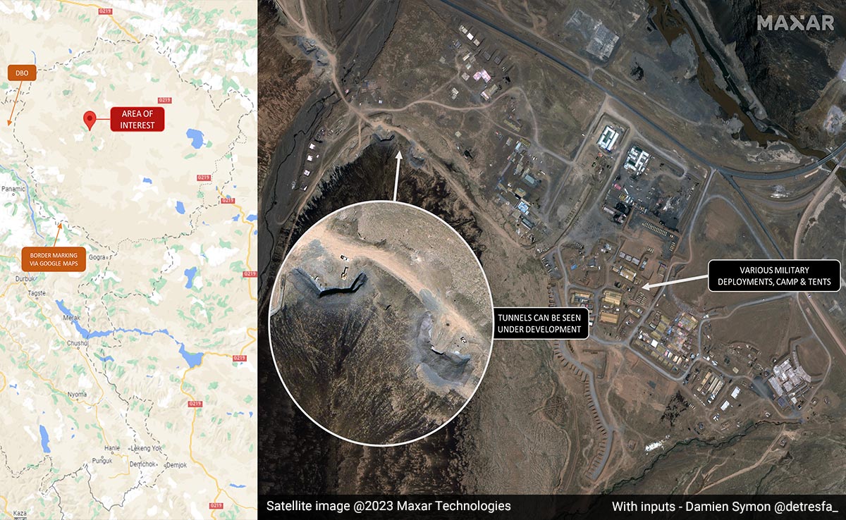
International geo-intelligence experts, who have analysed the images sourced by NDTV from Maxar for over a week, have identified the presence of at least 11 portals or shafts bored into the rockface on both banks of the river valley.
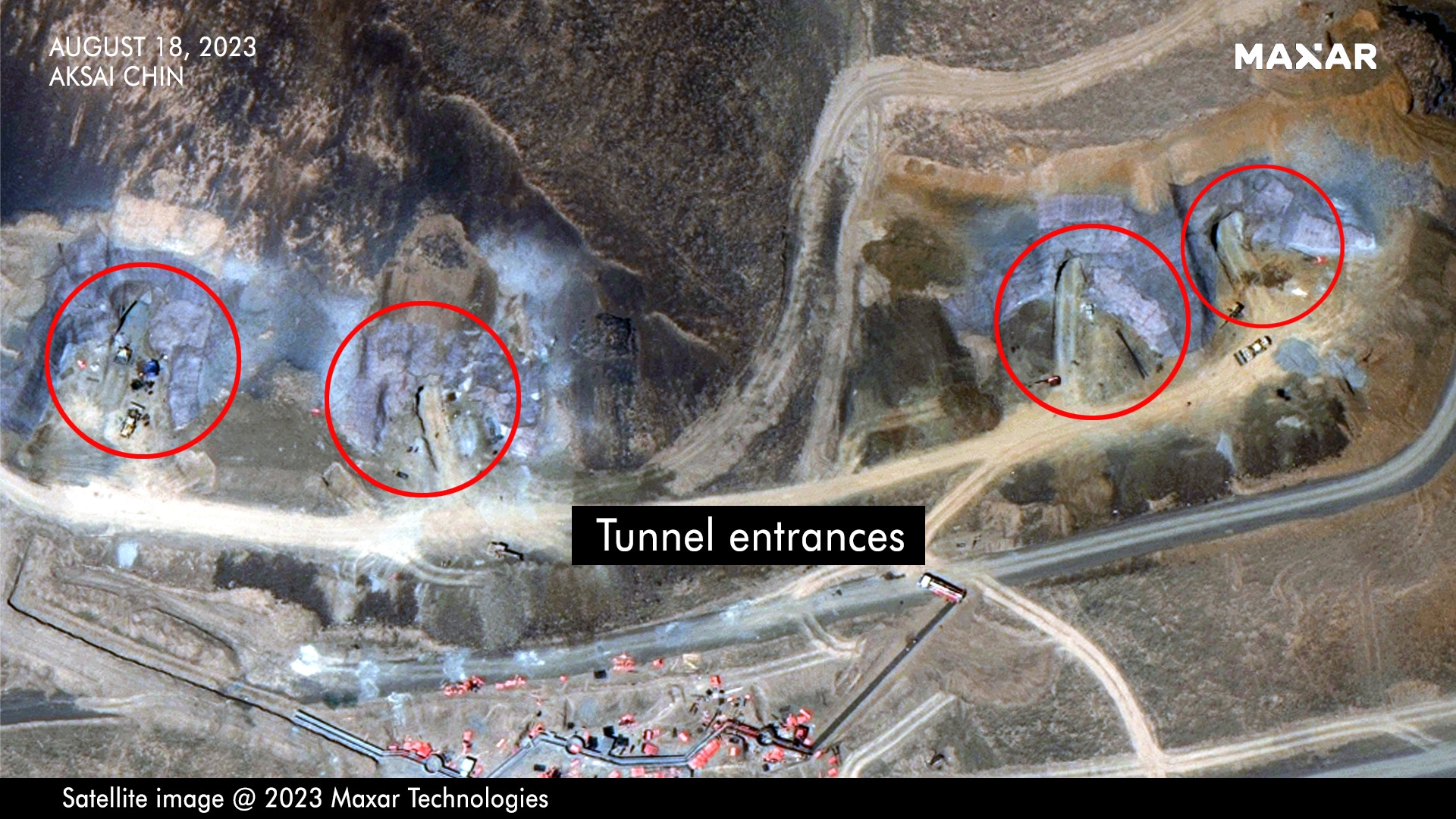
Satellite images indicate the existence of at least 11 shafts bored into the rockface. Several earth-moving machines visible (High res: Click for high-resolution pic)
The images show massive construction activity over the last few months and are a likely attempt to protect heavy weaponry and soldiers from Indian airstrikes and extended-range artillery.
In an exclusive interview with NDTV on Tuesday, Foreign Minister S Jaishankar rubbished China's latest move to claim Indian territory as its own by including Arunachal Pradesh and Aksai Chin in its new "standard map".
"China has put out maps with territories (that are) not theirs. (It is an) old habit. Just by putting out maps with parts of India... this doesn't change anything. Our government is very clear about what our territory is. Making absurd claims does not make other people's territories yours," Mr Jaishankar told NDTV.
Experts see China's activities in Aksai Chin as an act of desperation to offset India's advantage.
"By establishing underground facilities and developing subterranean infrastructure in such proximity to the border, Chinese strategists seem to be aiming to counterbalance the current advantage held by the Indian Air Force in Aksai Chin," says Damien Symon, a leading satellite imagery expert with The Intel Lab.
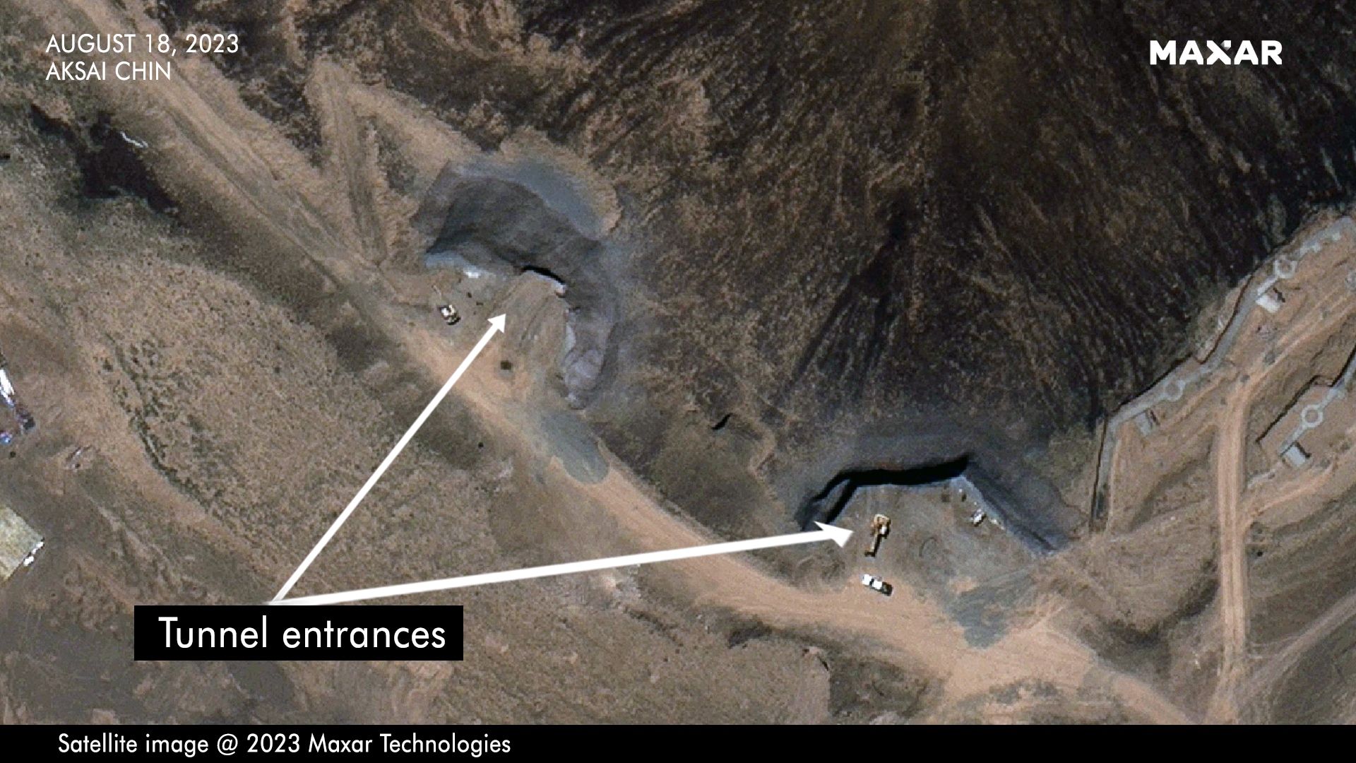
Close up of two tunnel entrances (High res: Click for high-resolution pic)
Sameer Joshi, the CEO of NewSpace Research & Technologies, a leading Indian drone start-up, agrees. "In the years since the Galwan clash, the Indian Army has effectively scaled up its offensive fire vectors, especially long-range tube and rocket artillery." The Chinese decision to carve into hillsides, Mr Joshi says, is directly linked to greater Indian offensive capability. "The massive construction activity, including hardened shelters, bunkers, tunnels, and the widening of roads is being done to mitigate this clear and present danger which the Indian Army has imposed on the Chinese deployment doctrine in Tibet," he explains.
The Indian Air Force operates a host of frontline airbases ranged against China across the Ladakh front. While Srinagar and Avantipura have traditionally been frontline IAF fighter bases, the Indian Air Force is also looking to extend the runway at the Air Landing Ground in Nyoma, which is located at an altitude of 13,700 feet near the Pangong Lake. Extending the runway at Nyoma would enable the IAF to host fighter aircraft less than 50 kilometres from the Line of Actual Control with China.
"It is clear that China is hardening its military presence in Ladakh against possible artillery and airstrikes in the event of a full-scale military escalation," says Sim Tack, the Chief Military Analyst at Force Analysis, which provides data and analysis on armed conflicts and defence policy. "We can see what are likely reinforced command positions and underground equipment storage facilities. Such facilities greatly enhance the Chinese ability to continue operations and limit attrition if an armed conflict were to break out in Ladakh."
Multiple berms and revetments of the site in December 2021 indicate that the location had been identified as a key staging point during the height of the India-China faceoff in Ladakh when Chinese forces had made multiple incursions into the Indian territory along the Line of Actual Control. This same area has now been completely transformed with massive, ongoing construction activity.
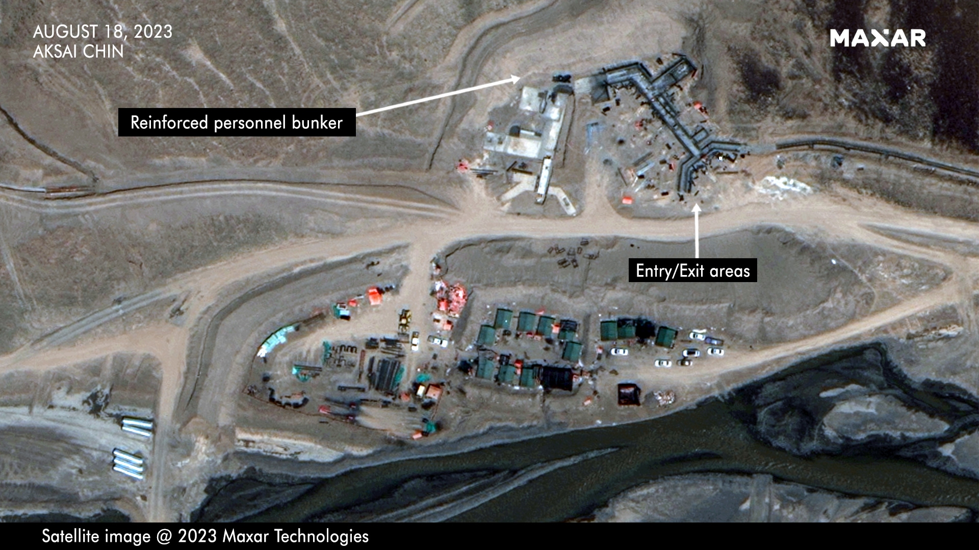
Multiple reinforced personnel bunkers have been carved into the hillside with entry and exit areas designed to dissipate the impact of pressure from bombardment (High res: Click for high-resolution pic)
The new images, from August 18, indicate the presence of four reinforced personnel bunkers constructed along the valley face, along with three tunnel areas, with two and five portals or tunnels at each site, carved onto the hillside. Heavy earth-moving machinery can be seen in multiple locations. A primary road, which cuts across the valley, has been substantially widened.
The images also show that the earth has been raised around the personnel bunkers to provide additional protection from direct attacks. Entry and exit areas have a distinctive fork design meant to dissipate the impact of pressure from bombardment and feature raised earth berms.
"China's creation of permanent bunkers and other fortifications in Aksai Chin meshes with its broader intransigence, with no sign that it is willing to climb down to some extent to end the extended military standoff with India," says Brahma Chellaney, among India's most authoritative watchers of China. "The construction activity in Aksai Chin, in fact, mirrors China's creation of new permanent military structures in other border areas extending from eastern Ladakh and the middle sector to the Arunachal-Tibet frontier."
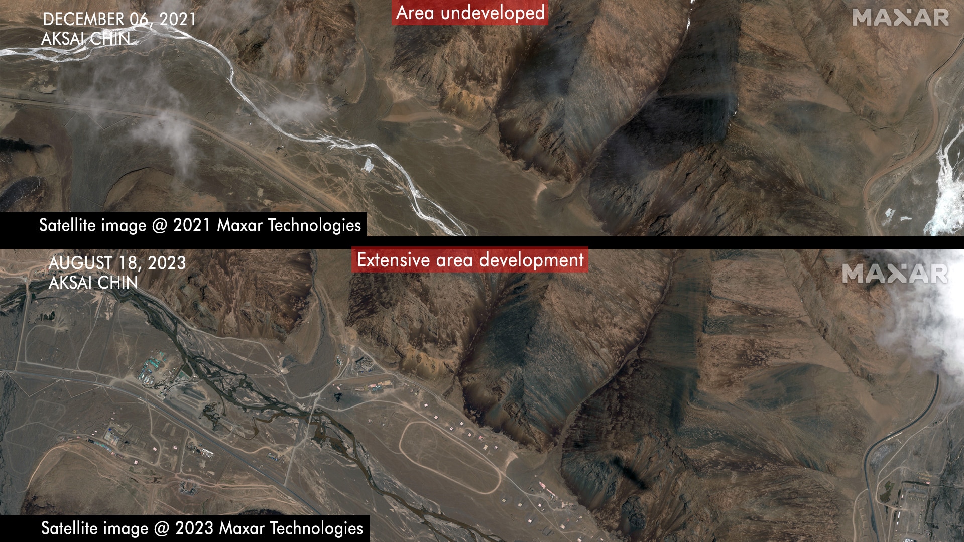
Satellite imagery from December 2021 of the river valley in Aksai Chin shows minimal construction activity. The site has been completely transformed by August 2023 (High res: Click for high-resolution pic)
While India and China have attempted to de-escalate the crisis along the Line of Actual Control by establishing no-patrol zones, the high-altitude Depsang plains remain a major source of concern for New Delhi since Chinese forces continue to prevent Indian soldiers in the area from reaching their pre-2020 patrol routes.
Though military-to-military talks on de-escalation may continue, China's decision to invest in hardened military complexes in close proximity to the Line of Actual Control appears to indicate that it is "digging in for the long haul". Jeff Smith, Director of the Asian Study Centre, who has seen the images in this report says, "Beijing seems determined to double down on a more aggressive LAC strategy, despite the considerable, perhaps irreversible, damage it has done to its relationship with India and despite facing considerable headwinds with a cratering economy, an accelerating rivalry with the U.S and an intensification of disputes in the Western Pacific."
Extensive Chinese military construction activity in Aksai Chin indicates Beijing's willingness to be permanently deployed in frontline areas (High res: Click for high-resolution pic)
In May 2020, Indian and Chinese soldiers clashed at multiple locations along the Line of Actual Control in Northeast Ladakh resulting in the most violent assaults since the 1962 war. On 15 June 2020, 20 Indian Army soldiers, including the commanding officer of an infantry battalion, were killed in hand-to-hand clashes in the Galwan Valley. The true number of Chinese casualties is believed to be significantly higher than the four deaths that Beijing officially accepted with investigative reports suggesting that at least 38 Chinese soldiers had been killed in the incident.
Since the 2020 clashes, India has vastly accelerated road and tunnel construction in the Ladakh region and is in the process of modernising and adapting high-altitude airfields. Significantly, New Delhi has completed the construction of the Darbuk-Shyok-Daulat Beg Oldi (DSDBO) road, which connects Leh with the sensitive Daulat Beg Oldie (DBO) post near the LAC. The Indian Air Force flies transport aircraft to DBO. The new road access means that both the base and soldiers deployed in the sensitive area can be maintained through a road line that has reduced travel time from two days to six hours. A new tunnel is also being constructed on this route.
China Goes Underground In Aksai Chin - What It Means For Indian Forces
Sixty kilometres east of the Depsang Plains in Northern Ladakh, Chinese forces have begun carving tunnels and shafts into a hillside along a narrow river valley to construct multiple reinforced shelters and bunkers for soldiers and weaponry.