The U.S. Navy has awarded the Woods Hole Oceanographic Institution a contract worth more than $12 million to develop unmanned undersea vehicles and buoys, along with a networked communications and data sharing infrastructure to link them all together. The project is ostensibly focused on developing a overall system to support enhanced monitoring of environmental changes in the Arctic for scientific purposes. However, it's not hard to see how this work could be at least a stepping stone to the creation of a wide-area persistent underwater surveillance system in this increasingly strategic region.
The Pentagon announced the award of the contract in a daily notice on Sept. 29, 2020. The Office of Naval Research (ONR) is managing what is officially called the Arctic Mobile Observing System (AMOS), which is also described as an "Innovative Naval Prototype" effort. ONR's secretive Netted Emulation of Multi-Element Signature (NEMESIS) electronic warfare program and its work on an electromagnetic railgun, which you can read about, respectively, here and here, are also an Innovative Naval Prototype projects.
"The work to be performed provides for the design, development, integration and testing of an acoustic navigation network, a distributed communication system, gateway buoy nodes and unmanned vehicle capabilities to support the Arctic Mobile Observing System," according to the Pentagon's contracting notice. Woods Hole's work under this contract is expected to wrap up by the end of the 2024 Fiscal Year.
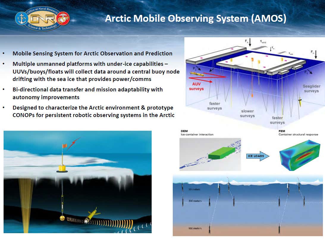
ONR envisions the AMOS prototype as consisting of various kinds of unmanned undersea vehicles (UUV), including fully-autonomous types, along with fixed sensors. All of this would be tied together through a series of communications and data sharing nodes, suspended underwater underneath buoys installed on the surface of the ice. "AMOS will be designed to persist/endure for 12 months, have a sensing footprint goal of 100 km [approximately 62 miles] from the central node and have 2-way Arctic communications (vehicle to vehicle, vehicle to node and node to shore)," according to an official project website.
USN
An ONR briefing slide showing a very broad overview of the AMOS concept.
The primarily publicly-stated goal of the AMOS program, which began in 2018, is provide a means of readily monitoring and assessing what is going on underneath the ice in the Arctic across broad areas. Receding ice and other environmental changes in the region as a result of global climate change has led to increased U.S. military activities in the region and prompted a new demand to better understand what is going on above and below the surface. Just being able to predict when and where significant amounts of ice will develop, or recede, which can be influenced by underwater conditions, such as water temperature, could have significant impacts on naval operations in the far north.
"If the Navy’s thinking about having to run operations up there with submarines, surface vessels and aircraft, you really need to understand that operational environment," Scott Harper, ONR's Program Manager for Arctic and Global Prediction, told Defense News in an interview in May. “Where is that sea ice and how quickly is it retreating? And what is it doing to the upper water column in the ocean?"
"You have satellites that can look down at the surface of the Arctic Ocean and the sea ice conditions," Harper continued. "But what we don’t have [is] the ability to look under the ice and understand what the ocean conditions are, and that’s what we’re really trying to enable with Arctic Mobile Observing System prototype."
USN
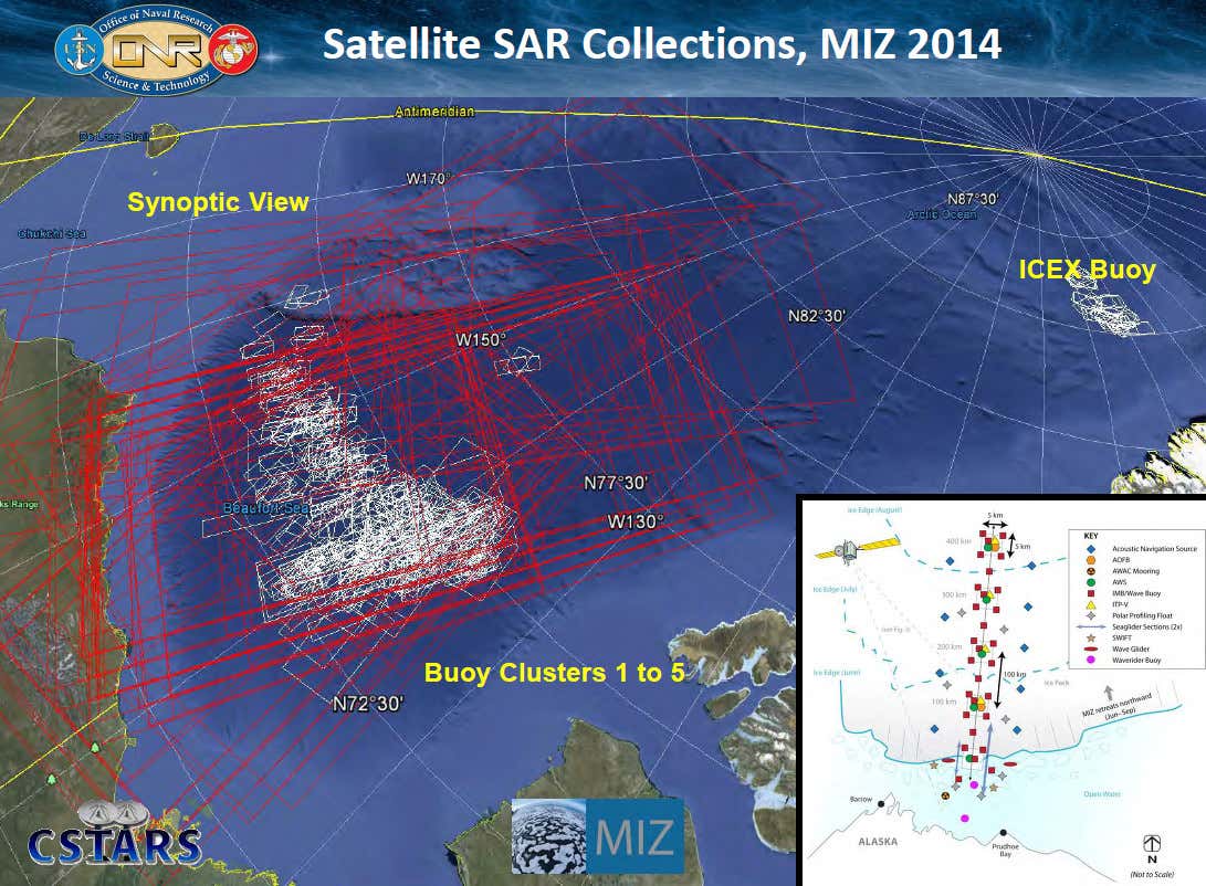
A map showing areas where satellites equipped with synthetic aperture radar (SAR) were used to collect imagery of ice coverage in the Arctic during ONR's earlier Marginal Ice Zone (MIZ) Initiative in 2014.
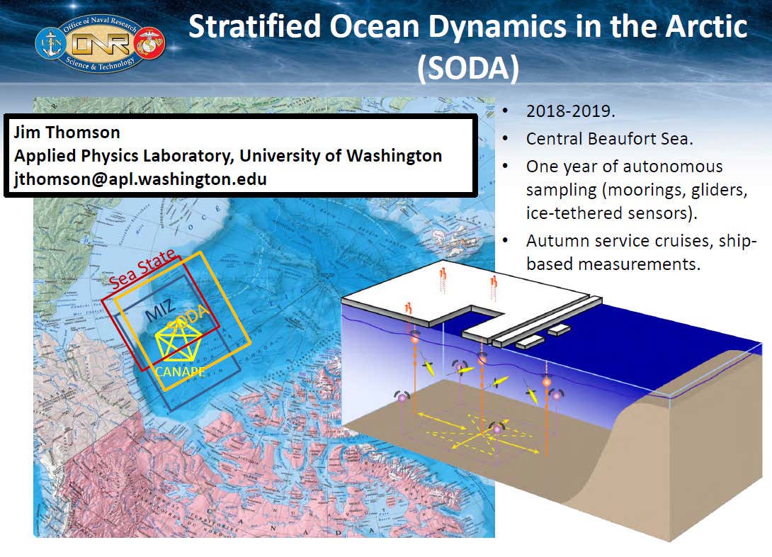
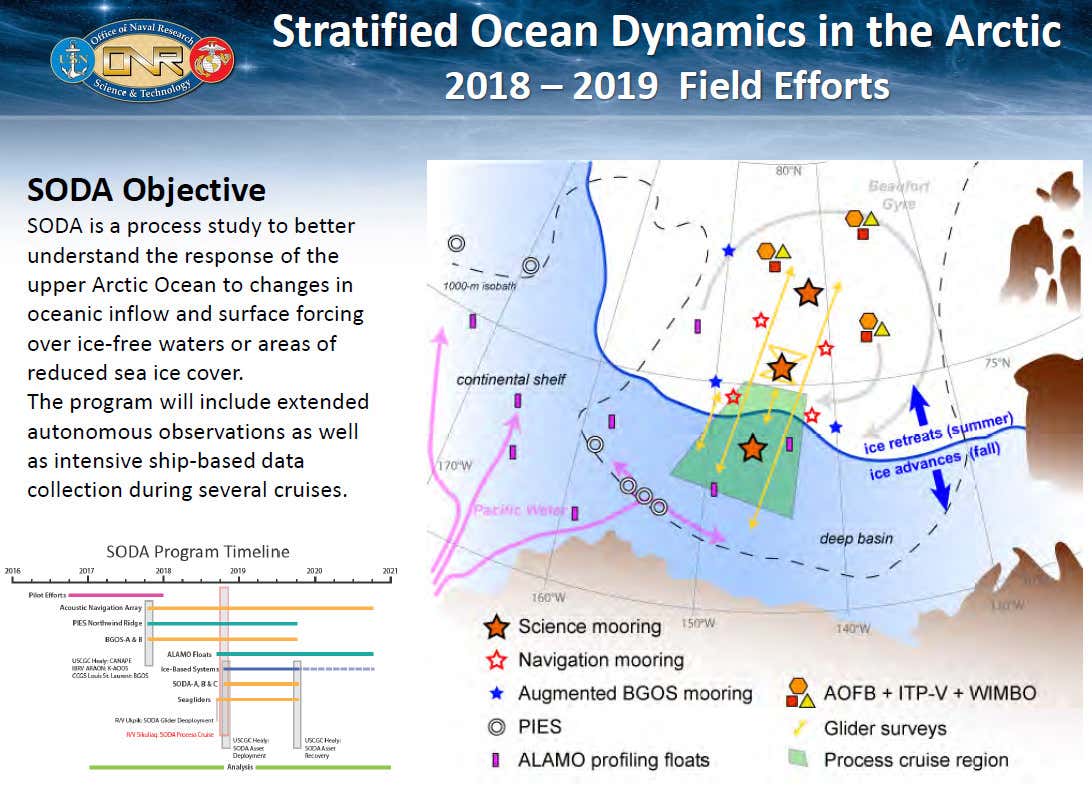
It's also worth noting that AMOS is the latest in a series of research efforts aimed at addressing these challenges that ONR conducted since 2011. The proposed overall architecture for this new prototype system is, in fact, very similar to the one developed for the Stratified Ocean Dynamics in the Arctic (SODA) experiment in the Beaufort Sea, part of the Arctic Ocean, which concluded last year.
USN
USN
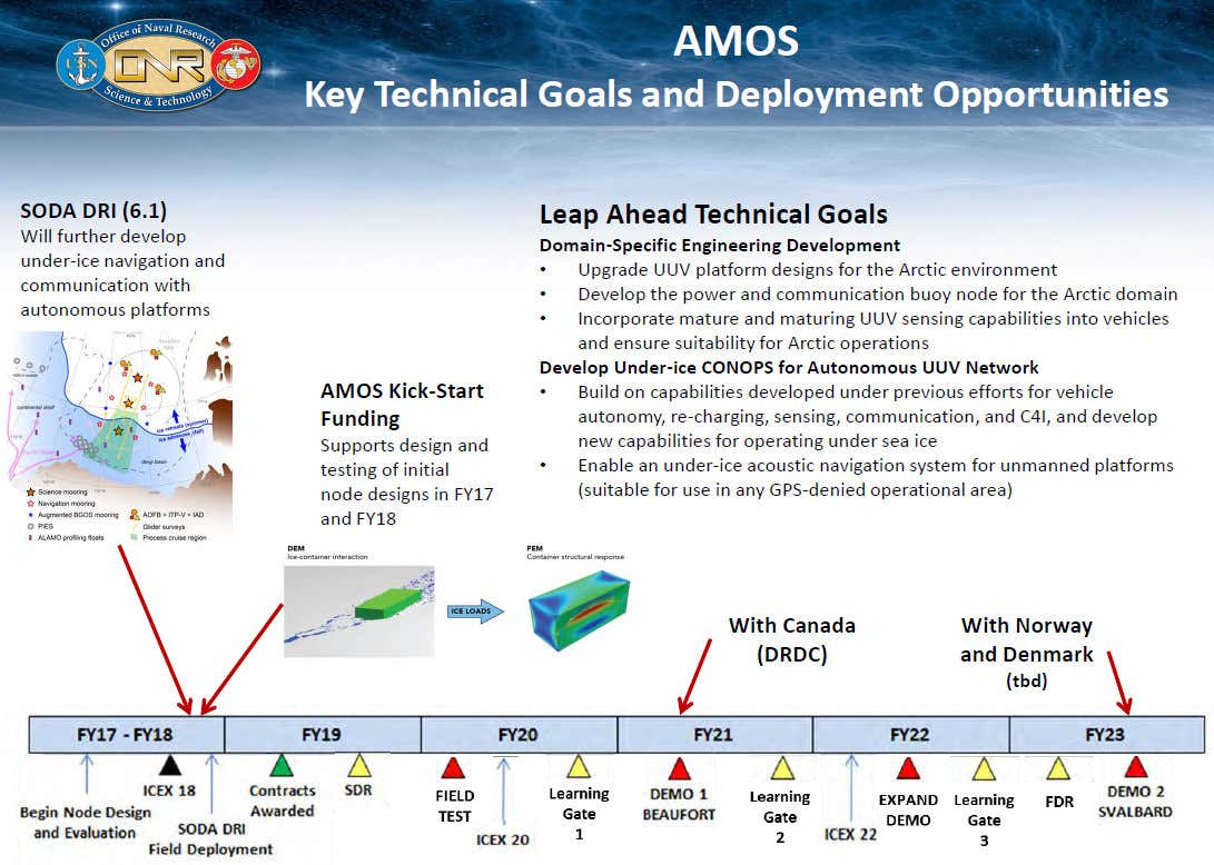
If the AMOS prototype successfully meets the Navy's goals, it possible that the service could expand the use of such networks in the Arctic or use lessons learned from this program to support follow-on efforts. ONR has indicated in the past that there are a number of "leap ahead technological goals" that will be necessary to achieve first in order for the system to work as intended.
These technological milestones include the development of UUVs and buoys that can withstand the extremely cold conditions in the region for extended periods of time. There is also a requirement for an "under-ice acoustic navigation system" to make up for the fact that UUVs operating deep under the ice will find it difficult, if not impossible to utilize GPS. Satellite coverage in the Arctic is limited, in general, which also limits access to satellite navigation and communications and data sharing networks.
USN
"The fact that we can put sensors out that will know where they are without having to come to the surface to get a GPS fix – because they can’t come to the surface because there’s sea ice there for nine months out of the year," ONR's Harper said in his May interview with Defense News. "That’s a big win."
"You can go out there and you can put your sensors in the ice, but a lot of times they’ll fail," Harper added. "And they’ll fail because they’ll get crushed in the ice or tipped over or toppled by changing ice conditions. And so the ability to deploy a buoy that is robust enough to survive the sea ice is one of the technological hurdles to doing this."
A system that networks together a fleet of UUVs, together with an array of fixed sensor and communication nodes for the purposes of monitoring activity underwater would also seem readily adaptable to other roles, such as intelligence, surveillance, and reconnaissance in Arctic waters, especially with regards to foreign submarine operations. Just being able to provide U.S. military commanders and American intelligence agencies with additional basic situational awareness of what's happening under the ice, as well as above it, could be a major boon.
USN
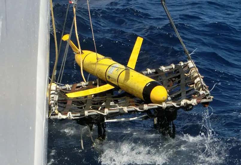
A US Navy ocean glider type unmanned undersea vehicle, commonly used for underwater survey purposes. Concept art associated with the AMOS programs suggests these could be adapted to Arctic conditions to support the prototype system.
US Army
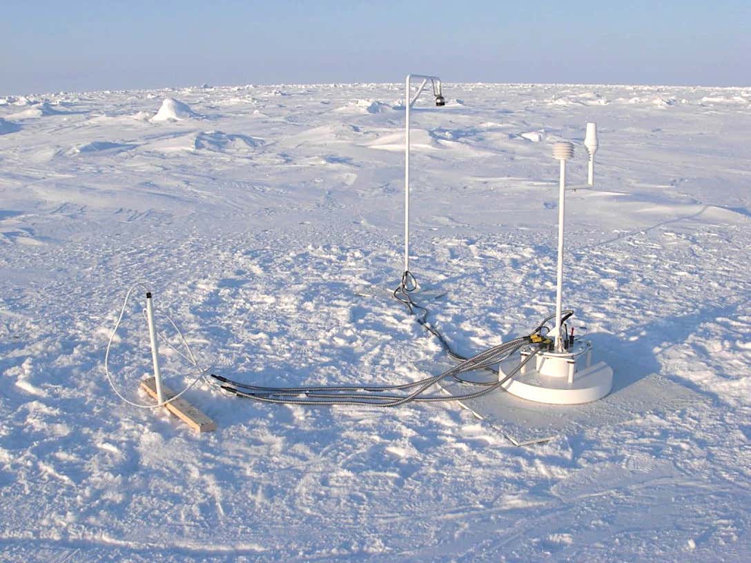
The top of an Ice Mass Balance Buoy, a type already in use to measure shifts in polar ice, which could be a starting place for the AMOS sensor and communication nodes.
“We have significant domain awareness challenges, and that really begins in the high latitudes,” retired Admiral Paul Zukunft, who was previously the Commandant of the U.S. Coast Guard, told a gathering at the 2020 Defense News Conference earlier in September. “Things start to get pretty dark once you get up higher than 72 degrees north.”
"We sent a national security cutter to patrol that region in a relatively ice-free portion of the season," he continued. "And we stumbled upon a joint exercise between Russia and China. Our intelligence community did not have awareness that this was going on. So we were the originators of this information and otherwise we would not have known. We need to continue to invest in domain awareness."
An armada of drone submarines patrolling even autonomously, tied together with a sensor network, could be a major step forward in gaining this kind of insight into how other navies are operating in the region. Navies around the world have long used the Arctic as a place to conduct discreet submarine operations that are difficult for potential adversaries to monitor.
In many ways, this adaptation of AMOS would mirror other Navy efforts to develop new and improved underwater sensor networks, with both fixed nodes and unmanned vehicles, to help monitor submarine traffic and other maritime movements across broad areas of the open ocean.
ThayerMahan
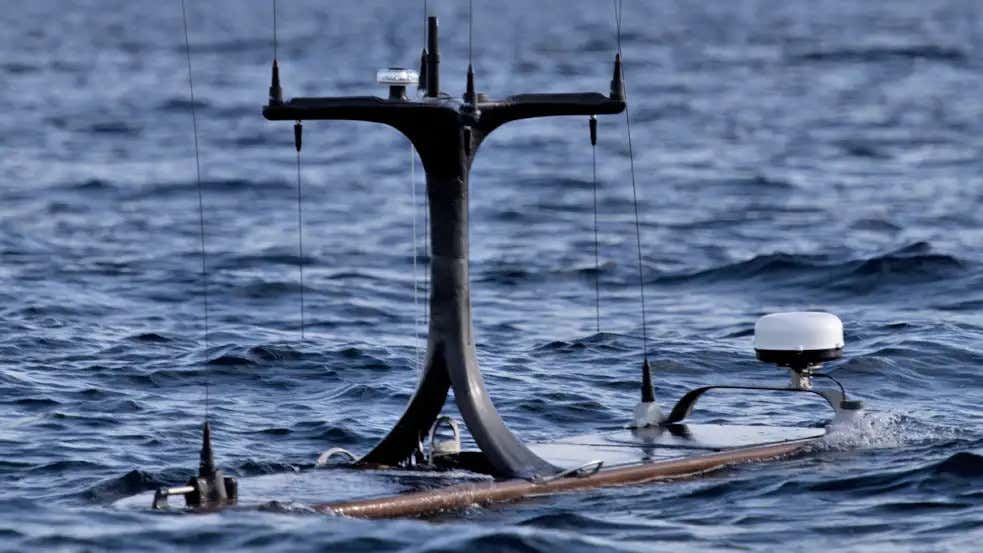
A ThayerMahan SeaWatch autonomous wave glider type unmanned vehicle, which the Navy is also experimenting with as a means of conducting maritime surveillance across a broad area.
The Navy is hardly the only one looking in expanding its underwater infrastructure, both in the Arctic and elsewhere. Russia is reportedly working on various projects in this vein in the Arctic, including potential underwater facilities and nuclear reactors to power them, that are again ostensibly for research purposes, but could easily have military applications. The Chinese have also established underwater monitoring stations, officially for scientific research, in the Pacific that could also be used to collect information about the goings and comings of foreign submarines and other vessels.
When it comes to the Arctic, Russia is steadily expanding its overall military footprint in the region with the establishment of a constellation of bases, many of which are still growing significantly in size and scope. Work is notably in progress to dramatically extend the runway at Nagurskoye Air Base, Russia's northernmost outpost, which you can read more in this past War Zone piece.
Competition in the Arctic region will only grow in the near future as global climate change makes it more accessible, in general, opening up a host of new potential economic opportunities. This includes the exploitation of natural resources, from oil to fish, as well as lucrative maritime shipping routes.
All told, the Navy's AMOS project looks set to be an important effort, both with regards to its immediate objectives to collect important information about Arctic conditions and as a stepping stone to further developments to support an increasing U.S. military presence in the region.

 www.thedrive.com
The Pentagon announced the award of the contract in a daily notice on Sept. 29, 2020. The Office of Naval Research (ONR) is managing what is officially called the Arctic Mobile Observing System (AMOS), which is also described as an "Innovative Naval Prototype" effort. ONR's secretive Netted Emulation of Multi-Element Signature (NEMESIS) electronic warfare program and its work on an electromagnetic railgun, which you can read about, respectively, here and here, are also an Innovative Naval Prototype projects.
"The work to be performed provides for the design, development, integration and testing of an acoustic navigation network, a distributed communication system, gateway buoy nodes and unmanned vehicle capabilities to support the Arctic Mobile Observing System," according to the Pentagon's contracting notice. Woods Hole's work under this contract is expected to wrap up by the end of the 2024 Fiscal Year.
ONR envisions the AMOS prototype as consisting of various kinds of unmanned undersea vehicles (UUV), including fully-autonomous types, along with fixed sensors. All of this would be tied together through a series of communications and data sharing nodes, suspended underwater underneath buoys installed on the surface of the ice. "AMOS will be designed to persist/endure for 12 months, have a sensing footprint goal of 100 km [approximately 62 miles] from the central node and have 2-way Arctic communications (vehicle to vehicle, vehicle to node and node to shore)," according to an official project website.
USN
An ONR briefing slide showing a very broad overview of the AMOS concept.
The primarily publicly-stated goal of the AMOS program, which began in 2018, is provide a means of readily monitoring and assessing what is going on underneath the ice in the Arctic across broad areas. Receding ice and other environmental changes in the region as a result of global climate change has led to increased U.S. military activities in the region and prompted a new demand to better understand what is going on above and below the surface. Just being able to predict when and where significant amounts of ice will develop, or recede, which can be influenced by underwater conditions, such as water temperature, could have significant impacts on naval operations in the far north.
"If the Navy’s thinking about having to run operations up there with submarines, surface vessels and aircraft, you really need to understand that operational environment," Scott Harper, ONR's Program Manager for Arctic and Global Prediction, told Defense News in an interview in May. “Where is that sea ice and how quickly is it retreating? And what is it doing to the upper water column in the ocean?"
"You have satellites that can look down at the surface of the Arctic Ocean and the sea ice conditions," Harper continued. "But what we don’t have [is] the ability to look under the ice and understand what the ocean conditions are, and that’s what we’re really trying to enable with Arctic Mobile Observing System prototype."
USN
A map showing areas where satellites equipped with synthetic aperture radar (SAR) were used to collect imagery of ice coverage in the Arctic during ONR's earlier Marginal Ice Zone (MIZ) Initiative in 2014.
It's also worth noting that AMOS is the latest in a series of research efforts aimed at addressing these challenges that ONR conducted since 2011. The proposed overall architecture for this new prototype system is, in fact, very similar to the one developed for the Stratified Ocean Dynamics in the Arctic (SODA) experiment in the Beaufort Sea, part of the Arctic Ocean, which concluded last year.
USN
USN
If the AMOS prototype successfully meets the Navy's goals, it possible that the service could expand the use of such networks in the Arctic or use lessons learned from this program to support follow-on efforts. ONR has indicated in the past that there are a number of "leap ahead technological goals" that will be necessary to achieve first in order for the system to work as intended.
These technological milestones include the development of UUVs and buoys that can withstand the extremely cold conditions in the region for extended periods of time. There is also a requirement for an "under-ice acoustic navigation system" to make up for the fact that UUVs operating deep under the ice will find it difficult, if not impossible to utilize GPS. Satellite coverage in the Arctic is limited, in general, which also limits access to satellite navigation and communications and data sharing networks.
USN
"The fact that we can put sensors out that will know where they are without having to come to the surface to get a GPS fix – because they can’t come to the surface because there’s sea ice there for nine months out of the year," ONR's Harper said in his May interview with Defense News. "That’s a big win."
"You can go out there and you can put your sensors in the ice, but a lot of times they’ll fail," Harper added. "And they’ll fail because they’ll get crushed in the ice or tipped over or toppled by changing ice conditions. And so the ability to deploy a buoy that is robust enough to survive the sea ice is one of the technological hurdles to doing this."
A system that networks together a fleet of UUVs, together with an array of fixed sensor and communication nodes for the purposes of monitoring activity underwater would also seem readily adaptable to other roles, such as intelligence, surveillance, and reconnaissance in Arctic waters, especially with regards to foreign submarine operations. Just being able to provide U.S. military commanders and American intelligence agencies with additional basic situational awareness of what's happening under the ice, as well as above it, could be a major boon.
USN
A US Navy ocean glider type unmanned undersea vehicle, commonly used for underwater survey purposes. Concept art associated with the AMOS programs suggests these could be adapted to Arctic conditions to support the prototype system.
US Army
The top of an Ice Mass Balance Buoy, a type already in use to measure shifts in polar ice, which could be a starting place for the AMOS sensor and communication nodes.
“We have significant domain awareness challenges, and that really begins in the high latitudes,” retired Admiral Paul Zukunft, who was previously the Commandant of the U.S. Coast Guard, told a gathering at the 2020 Defense News Conference earlier in September. “Things start to get pretty dark once you get up higher than 72 degrees north.”
"We sent a national security cutter to patrol that region in a relatively ice-free portion of the season," he continued. "And we stumbled upon a joint exercise between Russia and China. Our intelligence community did not have awareness that this was going on. So we were the originators of this information and otherwise we would not have known. We need to continue to invest in domain awareness."
An armada of drone submarines patrolling even autonomously, tied together with a sensor network, could be a major step forward in gaining this kind of insight into how other navies are operating in the region. Navies around the world have long used the Arctic as a place to conduct discreet submarine operations that are difficult for potential adversaries to monitor.
In many ways, this adaptation of AMOS would mirror other Navy efforts to develop new and improved underwater sensor networks, with both fixed nodes and unmanned vehicles, to help monitor submarine traffic and other maritime movements across broad areas of the open ocean.
ThayerMahan
A ThayerMahan SeaWatch autonomous wave glider type unmanned vehicle, which the Navy is also experimenting with as a means of conducting maritime surveillance across a broad area.
The Navy is hardly the only one looking in expanding its underwater infrastructure, both in the Arctic and elsewhere. Russia is reportedly working on various projects in this vein in the Arctic, including potential underwater facilities and nuclear reactors to power them, that are again ostensibly for research purposes, but could easily have military applications. The Chinese have also established underwater monitoring stations, officially for scientific research, in the Pacific that could also be used to collect information about the goings and comings of foreign submarines and other vessels.
When it comes to the Arctic, Russia is steadily expanding its overall military footprint in the region with the establishment of a constellation of bases, many of which are still growing significantly in size and scope. Work is notably in progress to dramatically extend the runway at Nagurskoye Air Base, Russia's northernmost outpost, which you can read more in this past War Zone piece.
Competition in the Arctic region will only grow in the near future as global climate change makes it more accessible, in general, opening up a host of new potential economic opportunities. This includes the exploitation of natural resources, from oil to fish, as well as lucrative maritime shipping routes.
All told, the Navy's AMOS project looks set to be an important effort, both with regards to its immediate objectives to collect important information about Arctic conditions and as a stepping stone to further developments to support an increasing U.S. military presence in the region.
The Navy Is Building A Network Of Drone Submarines And Sensor Buoys In The Arctic
As the Arctic literally and figuratively heats up, the Navy is looking to drastically increase its awareness of what is going on up there.
www.thedrive.com