• Forum restore complete (see latest announcement thread)

TR Air Forces|News & Discussion

hugh

Contributor
Messages
567
Reactions
17 1,533
Nation of residence
Turkey
Nation of origin
Turkey
The point about cloud cover is valid but this is a sensor fusion game where you combine optic sensors and SAR, the latter of which is not affected by clouds. For example, you can even now use ESA's Sentinel-1 to get free SAR data if the optical Sentinel-2 suffers from cloud cover. You definitely don't need humongous antennae either. Modern SAR satellites like ICEYE and Capella have 3-5 meter deployable reflectors and still get 0.25–1 m resolution through clouds.

With regards to orbits, you would actually want to stay in low earth orbit and have a constellation for this type of task so that you shorten revisit times to minutes. Starlink has proven this type of density is feasible technically. If you were to go to geosynchronous orbit, you sacrifice a lot of geospatial resolution simply because you are that high up. This is why most observation satellites (except for meteorology) are at low earth orbit.

So, in theory, with a large enough LEO constellation combining SAR and optical (including NIR and other relevant infrared bands) and some efficient computer vision algorithms, you can detect stealth jets. It comes down to cost and engineering effort, but I bet somebody will do it in the end. In Turkey's case the areas you want to monitor are not that large (seas around us and Syria), so it should be quite doable at some time in the future if there is a will.
your answer reads like chatgpt. please use it as much as you desire(hell, i must be reading over 50 prompts daily) but don't paste it directly here. it is so obvious for the initiated. i already blocked a few people here for their incessant abuse(despite several warnings). i've never seen you doing it before. so please don't go that way.

to counter your last point, it does not matter if Turkey is big or as small as Vatican. that's not how LEO works. if you want constant coverage you need a constellation. and a LEO constellation cannot be regional, it has to be global. you can limit the constellation to lower latitudes and save some satellites from venturing the poles but, again, the satellites won't be stationary and will circle the earth.
 

godel44

Committed member
Messages
167
Reactions
8 505
Nation of residence
Turkey
Nation of origin
Turkey
your answer reads like chatgpt. please use it as much as you desire(hell, i must be reading over 50 prompts daily) but don't paste it directly here. it is so obvious for the initiated. i already blocked a few people here for their incessant abuse(despite several warnings). i've never seen you doing it before. so please don't go that way.

to counter your last point, it does not matter if Turkey is big or as small as Vatican. that's not how LEO works. if you want constant coverage you need a constellation. and a LEO constellation cannot be regional, it has to be global. you can limit the constellation to lower latitudes and save some satellites from venturing the poles but, again, the satellites won't be stationary and will circle the earth.
I wasn't using chatgpt mate. I was told in the past I come across as formal but I never was accused of that specifically before.

Regarding your point about LEO: It should have been obvious that I am not talking about LEO satellites staying above one specific region. I was talking about the constellation constantly imaging one specific region. You can design a LEO constellation with inclined orbits so that it passes over your area of interest frequently. That way you always get coverage from at least one satellite in the constellation. So while the individual LEO sat circles the whole Earth, the constellation will always get image from the area of interest. While you dismiss this as "that's not how LEO works," this is common practice in space industry. And yes, Turkey's seas being a smaller area than, say, the whole Pacific Ocean does make Turkey's job easier than America's.
 

hugh

Contributor
Messages
567
Reactions
17 1,533
Nation of residence
Turkey
Nation of origin
Turkey
Regarding your point about LEO: It should have been obvious that I am not talking about LEO satellites staying above one specific region. I was talking about the constellation constantly imaging one specific region. You can design a LEO constellation with inclined orbits so that it passes over your area of interest frequently. That way you always get coverage from at least one satellite in the constellation. So while the individual LEO sat circles the whole Earth, the constellation will always get image from the area of interest. While you dismiss this as "that's not how LEO works," this is common practice in space industry. And yes, Turkey's seas being a smaller area than, say, the whole Pacific Ocean does make Turkey's job easier than America's.
this is wrong. you cannot have a LEO constellation that has more satellites passing over your region than other regions. what you can do, at most, is, like i said, launch your satellites to lower latitude(inclination) orbits so that you don't have to serve polar regions. but the satellites will visit Brazil as often as they visit Syria.

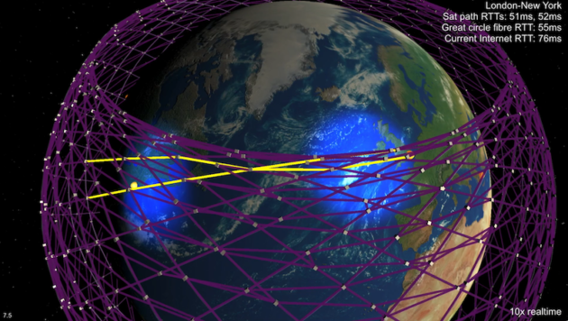
This is how a LEO constellation looks like. If we optimize it to use in our region, the top(highest inclination) satellites would not be included in our solution and serve only between, say, -50 and 50 degrees latitudes, which still wouldn't make sense to me as it would leave out Russia.

190208-starlink-630x356.png


If you're not agreeing with this, please point me to a LEO constellation that has regional coverage and not global, and by regional I mean a specific area(like a country or continent), not an area covered between two latitudes.
 

godel44

Committed member
Messages
167
Reactions
8 505
Nation of residence
Turkey
Nation of origin
Turkey
this is wrong. you cannot have a LEO constellation that has more satellites passing over your region than other regions. what you can do, at most, is, like i said, launch your satellites to lower latitude(inclination) orbits so that you don't have to serve polar regions. but the satellites will visit Brazil as often as they visit Syria.

This is how a LEO constellation looks like. If we optimize it to use in our region, the top(highest inclination) satellites would not be included in our solution and serve only between, say, -50 and 50 degrees latitudes, which still wouldn't make sense to me as it would leave out Russia.

190208-starlink-630x356.png


If you're not agreeing with this, please point me to a LEO constellation that has regional coverage and not global, and by regional I mean a specific area(like a country or continent), not an area covered between two latitudes.
I don't want to veer off too much from the topic of the thread but I will give a final reply as you are either moving goalposts or honestly not understanding what I am saying. When I say "regional" I don't mean satellites that stay fixed above a region and don't pass over other regions. These LEO satellites still orbit around Earth and cover the whole latitude band but their revisit frequency is optimized for a certain region. You can do this with inclinations that skip the poles and clustering RAANs so the sats in the constellation visit the region one after another. You can even take images of the area from other orbits off-nadir depending on sensors you have onboard. In your example, even if the satellites overfly other regions (say Brazil), the constellation can still hit Syria reliably without significant gaps.

As I said, this is common practice and nothing controversial, but if you insist on an example, the ICEYE constellation I mentioned previously serves as an example. When the war in Ukraine started, they tasked multiple (already existing) SAR satellites to that region and started getting hourly passes. So Ukraine got almost continuous SAR access. Other countries in the same latitude band can potentially get the same frequency of access but that is not the mission. If you still object to this existing, I would refer you to talk to them.
 

Yasar_TR

Experienced member
Staff member
Administrator
Messages
4,280
Reactions
263 22,349
Nation of residence
United Kingdom
Nation of origin
Turkey
The point about cloud cover is valid but this is a sensor fusion game where you combine optic sensors and SAR, the latter of which is not affected by clouds. For example, you can even now use ESA's Sentinel-1 to get free SAR data if the optical Sentinel-2 suffers from cloud cover. You definitely don't need humongous antennae either. Modern SAR satellites like ICEYE and Capella have 3-5 meter deployable reflectors and still get 0.25–1 m resolution through clouds.
Sentinel 1 Antenna is 0.821m x 12.3m. At 693km altitude for a 400km wide sweep it gives 40m x 40m resolution. For a 100km wide sweep you would get 20m x 20m resolution. For a 80km wide sweep the resolution increases to 5m x 5m. Originally developed to stop ship collisions; Sentinel-1 does this by receiving Automatic Identification Signals from ships directly. (I don’t think enemy will send signals to your satellite) . Due to its SAR capability it is also used in weather forecasting and terrain mapping. This is a civilian radar system with limited visit times. Revisit time could be 6-12 days.

taken from NASA:
quote:
The spatial resolution of radar data is directly related to the ratio of the sensor wavelength to the length of the sensor's antenna. For a given wavelength, the longer the antenna, the higher the spatial resolution. From a satellite in space operating at a wavelength of about 5 cm (C-band radar), in order to get a spatial resolution of 10 m, you would need a radar antenna about 4,250 m long. (That's over 47 football fields!)
unquote.

So with SAR this difficulty is alleviated to a degree by using the right frequency and sacrificing swath length and resolution.

A military use SAR satellite like German Lupe is comparatively small but has good resolution. There are 5 of them. They take swath length of 8km at a time and to put together a ground map takes 10 hours. This is the time it takes from when an image is requested to when the resulting image is delivered to the user

ICEYE satellites may give near real time imaging with a full complement of a large constellation. If 30 satellites were sweeping say London, that is still only a revisit of 15 times a day. In real life delivery of image to user times can be as long as 1 hour to 8 hours. As of January 2025 there were 44 ICEYE satellites with a further 20 to be placed. To get good resolution the swath distances are very short; 5km being typical for strip sweep.
Starlink has proven this type of density is feasible technically. If you were to go to geosynchronous orbit, you sacrifice a lot of geospatial resolution simply because you are that high up. This is why most observation satellites (except for meteorology) are at low earth orbit.
Starlink is going to place 30thousand + satellites in space to give instant total coverage and no delay. At the moment their coverage is a bit sketchy and has to divert and redirect satellite angles to specific areas to provide continuous signal.

Your last paragraph sums it up. May be one day!
 
Last edited:

godel44

Committed member
Messages
167
Reactions
8 505
Nation of residence
Turkey
Nation of origin
Turkey
Sentinel 1 Antenna is 0.821m x 12.3m. At 693km altitude for a 400km wide sweep it gives 40m x 40m resolution. For a 100km wide sweep you would get 20m x 20m resolution. For a 80km wide sweep the resolution increases to 5m x 5m. Originally developed to stop ship collisions; Sentinel-1 does this by receiving Automatic Identification Signals from ships directly. (I don’t think enemy will send signals to your satellite) . Due to its SAR capability it is also used in weather forecasting and terrain mapping. This is a civilian radar system with limited visit times. Revisit time could be 6-12 days.

taken from NASA:
quote:
The spatial resolution of radar data is directly related to the ratio of the sensor wavelength to the length of the sensor's antenna. For a given wavelength, the longer the antenna, the higher the spatial resolution. From a satellite in space operating at a wavelength of about 5 cm (C-band radar), in order to get a spatial resolution of 10 m, you would need a radar antenna about 4,250 m long. (That's over 47 football fields!)
unquote.

So with SAR this difficulty is alleviated to a degree by using the right frequency and sacrificing swath length and resolution.

A military use SAR satellite like German Lupe is comparatively small but has good resolution. There are 5 of them. They take swath length of 8km at a time and to put together a ground map takes 10 hours. This is the time it takes from when an image is requested to when the resulting image is delivered to the user

Starlink is going to place 30thousand + satellites in space to give instant total coverage and no delay. At the moment their coverage is a bit sketchy and has to divert and redirect satellite angles to specific areas to provide continuous signal.

Your last paragraph sums it up. May be one day!
Agree on much of what you said. But if I may nitpick:
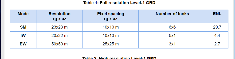
- The 40m resolution you mention for Sentinel-1 is not quite correct. Sentinel-1 actually provides data in different modes with different resolutions (ground ranges ranging from 5m to 20m) and the one you would use for this task is the Stripmap mode with Single Look Complex processing, which gives you a 4m x 4m resolution (range x azimuth).
- The detection of ships with AIS is like an add-on feature and it's not relevant here. But, ships with their transponders off can still be detected with SAR. I had once written a deep learning algorithm to do just that using Sentinel-1.
- This is actually a moot point since I just used Sentinel-1 as an example of a very popular SAR satellite that can see through clouds without a huge antenna. For the detection of stealth jets it is obviously not viable due to long revisit times. That's why I said a special constellation of satellites. Also probably not with C-SAR but with L-SAR as RCS of stealth fighters tend to be optimized for C band anyway.
- Agree on the computation challenge, but things tend to improve fast in that domain.

But yes, one day.
 

Yasar_TR

Experienced member
Staff member
Administrator
Messages
4,280
Reactions
263 22,349
Nation of residence
United Kingdom
Nation of origin
Turkey
Agree on much of what you said. But if I may nitpick:
- The 40m resolution you mention for Sentinel-1 is not quite correct. Sentinel-1 actually provides data in different modes with different resolutions (ground ranges ranging from 5m to 20m) and the one you would use for this task is the Stripmap mode with Single Look Complex processing, which gives you a 4m x 4m resolution (range x azimuth).
- The detection of ships with AIS is like an add-on feature and it's not relevant here. But, ships with their transponders off can still be detected with SAR. I had once written a deep learning algorithm to do just that using Sentinel-1.
- This is actually a moot point since I just used Sentinel-1 as an example of a very popular SAR satellite that can see through clouds without a huge antenna. For the detection of stealth jets it is obviously not viable due to long revisit times. That's why I said a special constellation of satellites. Also probably not with C-SAR but with L-SAR as RCS of stealth fighters tend to be optimized for C band anyway.
- Agree on the computation challenge, but things tend to improve fast in that domain.

But yes, one day.
1754732694059.jpeg


Well, this site gives values similar to what I had read and shared in my previous post.
But it is all retrospective. More area sweep at a time, less resolution
Narrower swath distances, better resolution. More visits better resolution.
Just like ICEYE constellations. The minute you narrow swath to 5km your resolution increases to 0.25metres. Increase swath to 100km, you get 15m resolution.
A big problem with these is getting real time data, and response times.
When these issues are resolved, then we may start seeing the light.

But the rate we are going at the moment is rather alarming. Every country trying to put satellites up there is cluttering the space near our planet. Already space debris is a problem. It is disturbing that we may get stuck at one point because of the junk that has gathered up there. These satellites have finite lives, 10-15 years being common. Once they run out of steam, they start gradually losing orbit altitude until they burn in atmosphere. But that too is a long time and it is uncontrolled.
 

Sanchez

Experienced member
Moderator
Think Tank Analyst
DefenceHub Diplomat
Messages
4,193
Reactions
127 19,054
Nation of residence
Turkey
Nation of origin
Turkey
Are there any news either the eurofighter?
Nope. Nothing new so far after the MoU that was signed in Idef. Detailing and finalizing the deal still can take a lot of time.
 

IC3M@N FX

Contributor
Messages
701
Reactions
3 30 1,432
Nation of residence
Germany
Nation of origin
Turkey
The F-16 Block 70 no longer makes sense as a temporary solution in my opinion.

The TAI KAAN is the central project for the future. It strengthens technological independence and domestic industry, but it will still take years before it is ready for deployment in significant numbers – that is clear to all of us.

The Eurofighter offers the greatest opportunity in the meantime: Memorandum of Understanding with UK only makes sense if concessions beyond the pure purchase are involved. These could include:

Interface approvals (own IFF systems, EW/ECM and national weapons integration)

Extended maintenance and repair rights

Manufacture of spare parts in our own country

If everything goes well, we will have a custom Eurofighter like the Israelis have with the F-35I.

These points would be crucial in terms of industrial policy because they reduce dependence, enhance our own aviation industry, and could potentially lead to further orders. Turkey needs redundancy. TAI KAAN as a manned fighter aircraft until 2040+ would not be enough; a second strong platform is needed. The Eurofighter would be ideal, as the F-16 is being phased out. Finally, through cannibalization, 80-100 Özgür II aircraft can be kept until 2040+ until the airframe is completely dead, and that will also be sufficient for NATO's nuclear participation until then.
 

Sanchez

Experienced member
Moderator
Think Tank Analyst
DefenceHub Diplomat
Messages
4,193
Reactions
127 19,054
Nation of residence
Turkey
Nation of origin
Turkey
Memorandum of Understanding with UK only makes sense if concessions beyond the pure purchase are involved.
Why?

Interface approvals (own IFF systems, EW/ECM and national weapons integration)

Extended maintenance and repair rights

Manufacture of spare parts in our own country

If everything goes well, we will have a custom Eurofighter like the Israelis have with the F-35I.
These would take at least 5+ years to set up, create, integrate. There's no way the first 40 aircraft come with our own EW.
 

Yasar_TR

Experienced member
Staff member
Administrator
Messages
4,280
Reactions
263 22,349
Nation of residence
United Kingdom
Nation of origin
Turkey
Why?


These would take at least 5+ years to set up, create, integrate. There's no way the first 40 aircraft come with our own EW.
IFF, EW/ECM and local munitions integration can be done very quickly if the sort codes are accessed. But if UK will sell the ECRS-MK2 radar with the planes only local IFF system and munitions need to be integrated.

Extensive maintenance and repair shop system can be set up within a year whilst the team are trained.

Manufacturing spare parts is a sticky point. Most aircraft manufacturers make their money with these. But a compromise can be achieved if a JV can be set up. This may take a few years. But Tusas for fuselage and TEI and Kale for engine may help there.

Since F16V70 order is on hold, the quantity of Typhoon order may double or more. That should give more leeway to negotiate a more favourable contract, allowing us more freedom with the plane.

Tusas site states that 48 KAAN aircrafts to Indonesia will all be delivered in 120 months after 26July 2025, furnished with locally manufactured engines. Tusas has also stated that the local KAAN engine has to be ready and accepted by 2032 to meet this deadline.

If F110 engine sale is blocked, we won’t have an engine to fit in to our KAANs until 2032. To build up a squadron strength may take a couple of years if we are to meet export commitments too.
That means no modern jets for another 9-10 years.

So purchasing 80-100 Typhoons will keep our airforce in good shape until our 100% indigenously manufactured planes are ready. Otherwise we will be stuck with locally upgraded f16s.
 
Last edited:

2033

Committed member
Messages
204
Reactions
4 417
Nation of residence
Turkey
Nation of origin
Turkey
IFF, EW/ECM and local munitions integration can be done very quickly if the sort codes are accessed. But if UK will sell the ECRS-MK2 radar with the planes only local IFF system and munitions need to be integrated.

Extensive maintenance and repair shop system can be set up within a year whilst the team are trained.

Manufacturing spare parts is a sticky point. Most aircraft manufacturers make their money with these. But a compromise can be achieved if a JV can be set up. This may take a few years. But Tusas for fuselage and TEI and Kale for engine may help there.

Since F16V70 order is on hold, the quantity of Typhoon order may double or more. That should give more leeway to negotiate a more favourable contract, allowing us more freedom with the plane.

Tusas site states that 48 KAAN aircrafts to Indonesia will all be delivered in 120 months after 26July 2025, furnished with locally manufactured engines. Tusas has also stated that the local KAAN engine has to be ready and accepted by 2032 to meet this deadline.

If F110 engine sale is blocked, we won’t have an engine to fit in to our KAANs until 2032. To build up a squadron strength may take a couple of years if we are to meet export commitments too.
That means no modern jets for another 9-10 years.

So purchasing 80-100 Typhoons will keep our airforce in good shape until our 100% indigenously manufactured planes are ready. Otherwise we will be stuck with locally upgraded f16s.
As far as I understand, we won’t be acquiring either the Eurofighter or the F-16V. Is there any news about the Özgür-2 modernization?
 

Zafer

Experienced member
Messages
5,654
Reactions
15 8,712
Nation of residence
Turkey
Nation of origin
Turkey
We only need to make sure we can have an early crop of engines that can satisfy basic requirements while they still fall behind the best quality foreign engines. Like an 80% quality engine will take us to where we need to be in the short term. Can we do this by 2028, I believe we can.

We should also work on more variety in plane design, more of single engine and 3 or 4 engine designs should be worked on. When you have all the components available it would be foolish to not go for more capability.
 
Last edited:

Lool

Experienced member
Messages
3,547
Reactions
20 5,862
Nation of residence
Albania
Nation of origin
Albania
Anyone who believes that Turkey will potentially acquire F16V or F35, while jewish and greek lobby dominates congress and Trump's brain, then they are delusional

There is an extremely slight possibility for the Typhoons but I always know that the Germans, just like with most defence deals with Turkey, will try to sabotage it in the last minute

Turkey's only option is to continue with the F16 Ozgur program (which according to TAI, makes it equivalent to the Viper variant of the US) and try to get KAAN done somehow
 

Oublious

Experienced member
The Netherlands Correspondent
Messages
2,780
Reactions
15 6,101
Nation of residence
Nethelands
Nation of origin
Turkey
Today Kaner Kurt will asl that question to Ozgor Eksi in his interview about latest development about the f16 ans ef deal.
 

boredaf

Experienced member
Messages
2,271
Solutions
1
Reactions
42 6,661
Nation of residence
United Kingdom
Nation of origin
Turkey
Can we do this by 2028, I believe we can.
Based on what, exactly? An engine that only exist on paper, that relies on technologies we have yet to master in large scale production and one that (naturally, since it doesn't exist) has been through no tests can be installed on our 100 million dollar jets 4 years before the last estimates of the officials?

Seriously, what is the source this claim that has any basis on reality that we are living in right now? How is it possible? What makes it possible?
 

Ripley

Contributor
Think Tank Analyst
DefenceHub Diplomat
Messages
1,431
Reactions
51 4,581
Nation of residence
United States of America
Nation of origin
Turkey
And what are the legal consequences of not delivering KAANs within 120 months? Will Turkey face financial penalties from Indonesia when we overshoot the deadline? I have searched and haven’t found any detail on that.
 
Top Bottom